Soubor:Equatorial Guinea provinces numbered.png
Z Multimediaexpo.cz
Větší rozlišení není k dispozici.
Equatorial_Guinea_provinces_numbered.png (rozměr: 300 × 176 pixelů, velikost souboru: 6 kB, MIME typ: image/png)
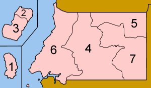
Mapa + Description: Map of the provinces of Equatorial Guinea, numbered in Spanish (native language) alphabetical order, mostly compatible with English. The islands are farther away from the mainland and each other than represented on this map, hence the lines between them.
- Annobón
- Bioko Norte
- Bioko Sur
- Centro Sur
- Kié-Ntem
- Litoral
- Wele-Nzas
- Date: June 2005
- Source: Self-made, traced from public domain UN or CIA maps.
- Author: User:Golbez
+ pochází z Wikimedia Commons, kde má status – Creative Commons Attribution-Share Alike 2.5 Generic, 2.0 Generic and 1.0 Generic license.
Historie souboru
Kliknutím na datum a čas se zobrazí tehdejší verze souboru.
| Datum a čas | Náhled | Rozměry | Uživatel | Komentář | |
|---|---|---|---|---|---|
| současná | 21. 9. 2015, 17:06 | | 300×176 (6 kB) | Sysop (diskuse | příspěvky) | (Mapa + + pochází z Wikimedia Commons, kde má status – Kategorie:PD fotografie ) |
- Editovat tento soubor v externím programu (Více informací najdete v nápovědě pro nastavení.)
Odkazy na soubor
Na soubor odkazuje tato stránka:


