V encyklopedii Allmultimedia.cz byl aktivován špičkový grafický skin Foreground.
Foreground plně podporuje – RWD, HTML 5.0, Super Galerii a YouTube 2.0 !
Foreground plně podporuje – RWD, HTML 5.0, Super Galerii a YouTube 2.0 !
Soubor:Himalayas.jpg
Z Multimediaexpo.cz
Velikost tohoto náhledu je: 800 × 527 pixelů
Obrázek ve vyšším rozlišení (rozměr: 3 032 × 1 998 pixelů, velikost souboru: 3,78 MB, MIME typ: image/jpeg)
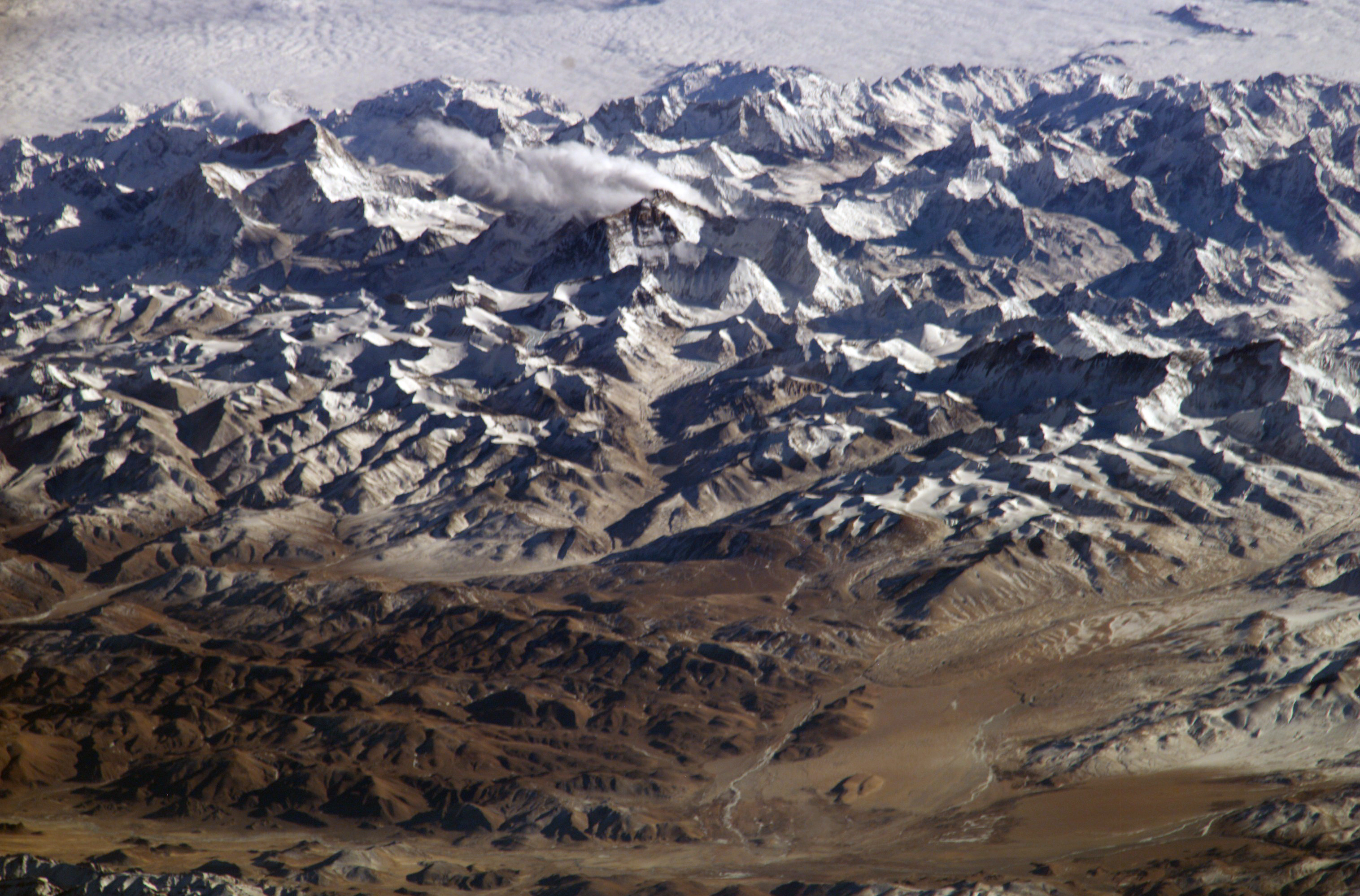
Fotografie + Description: Deutsch: Der Himalaya von oben gesehen
- English: Himalaya from the International Space Station. In addition to looking heavenward, NASA helps the world see the Earth in ways no one else can. Astronauts on board the International Space Station recently took advantage of their unique vantage point to photograph the Himalayas, looking south from over the Tibetan Plateau. The perspective is illustrated by the summits of Makalu [left (8,462 metres; 27,765 feet)], Everest [middle (8,848 metres; 29,035 feet)] , Lhotse [middle (8,516 metres; 27,939 feet)] and Cho Oyu [right (8,201 metres; 26,906 feet)] -- at the heights typically flown by commercial aircraft.
- Español: El Himalaya visto desde la Estación Espacial Internacional. La planicie tibetana en primer término. Se pueden apreciar las cumbres de Makalu (8 462 metres, en la izquierda), de el Everest (8 848 m, en el centro), el Lhotse (justo a la derecha del Everest, 8516 m) y el Cho Oyu (a la derecha del todo, 8 201 m de altitud).
- Français : L'Himalaya vu de la Station spatiale internationale. La NASA ne fait pas que regarder les étoiles, mais utilise aussi ses points de vues uniques pour observer la terre. Cette vue de l’Himalaya a été prise depuis la Station spatiale internationale, avec le plateau tibétain au premier plan. On peut voir les sommets du Makalu (8 462 mètres, à gauche), de l'Everest (8 848 m, au milieu), du Lhotse (juste à droite de l'Everest, 8516 m) et du Cho Oyu (tout à droite, 8 201 m d'altitude). L'altitude de ces sommets correspond aux altitudes de vol des avions de ligne.
- Suomi: Himalaja kansainväliseltä avaruusasemalta kuvattuna
- Italiano: L'Himalaya fotografata dalla stazione spaziale internazionale, con l'altopiano del Tibet in primo piano. Si possono notare le cime dei monti Makalu (8462 metri, in alto a sinistra), Everest (8848 metri, in centro), Lhotse (8516 metri, appena sopra l'Everest sulla foto) e Cho Oyu (8201 metri, a destra). Queste altezze corrispondono a quelle raggiunte dagli aerei di linea.
- Date: January 28, 2004, 10:01:59 GMT
- Author: NASA
+ pochází z Wikimedia Commons, kde má status – This file is in the public domain in the United States because it was solely created by NASA.
NASA copyright policy states that "NASA material is not protected by copyright unless noted".
(Use of NASA logos, insignia and emblems is restricted per U.S. law 14 CFR 1221)
NASA copyright policy states that "NASA material is not protected by copyright unless noted".
(Use of NASA logos, insignia and emblems is restricted per U.S. law 14 CFR 1221)
Historie souboru
Kliknutím na datum a čas se zobrazí tehdejší verze souboru.
| Datum a čas | Náhled | Rozměry | Uživatel | Komentář | |
|---|---|---|---|---|---|
| současná | 21. 5. 2013, 17:30 | | 3 032×1 998 (3,78 MB) | Sysop (diskuse | příspěvky) | (FILE1122) |
- Editovat tento soubor v externím programu (Více informací najdete v nápovědě pro nastavení.)
Odkazy na soubor
Na soubor odkazují tyto 2 stránky:


