V encyklopedii Allmultimedia.cz byl aktivován špičkový grafický skin Foreground.
Foreground plně podporuje – RWD, HTML 5.0, Super Galerii a YouTube 2.0 !
Foreground plně podporuje – RWD, HTML 5.0, Super Galerii a YouTube 2.0 !
Soubor:Map-Germany-1945.png
Z Multimediaexpo.cz
Velikost tohoto náhledu je: 706 × 600 pixelů
Obrázek ve vyšším rozlišení (rozměr: 2 000 × 1 699 pixelů, velikost souboru: 439 kB, MIME typ: image/png)
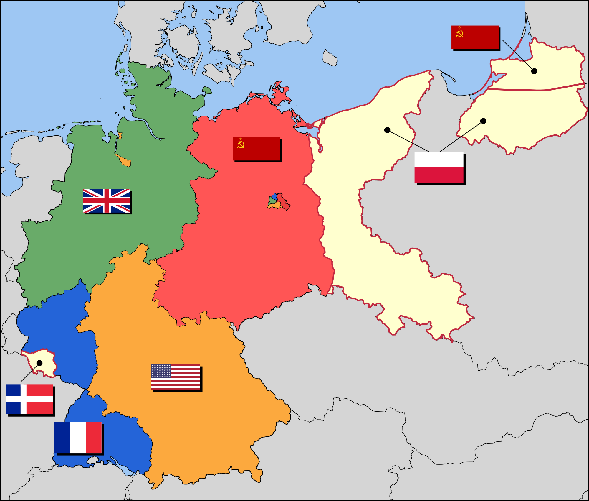
Mapa + English: Occupation zone borders in Germany, 1947. The territories east of the Oder-Neisse line, under Polish and Soviet administration/annexation, are shown as cream as is the likewise detached Saar protectorate. Berlin is the multinational area within the Soviet zone.
- Français : Carte des zones d'occupation de l'Allemagne : le protectorat français de la Sarre apparait en blanc-crème, comme la Silésie, la Poméranie et les autres régions allemandes orientales annexées par la Pologne et l'Union Soviétique.
- Deutsch: Grenzen der Besatzungszonen in Deutschland, 1947. Die Gebiete östlich der Oder-Neiße-Grenze, unter polnischer und sowjetischer Verwaltung/Annexion, sowie das Saar-Protektorat sind cremefarben dargestellt. Berlin ist ein multinationales Gebiet inmitten der sowjetischen Besatzungszone.
- Date: 17 March 2008 (original upload date)
- Source: Based on map data of the IEG-Maps project (Andreas Kunz, B. Johnen and Joachim Robert Moeschl: University of Mainz) - www.ieg-maps.uni-mainz.de.
- Author: en:User:52 Pickup
+ pochází z Wikimedia Commons, kde má status – This file is licensed under the Creative Commons Attribution-Share Alike 2.5 Generic license. (CC BY-SA 2.5)
Historie souboru
Kliknutím na datum a čas se zobrazí tehdejší verze souboru.
| Datum a čas | Náhled | Rozměry | Uživatel | Komentář | |
|---|---|---|---|---|---|
| současná | 28. 6. 2020, 09:17 | | 2 000×1 699 (439 kB) | Sysop (diskuse | příspěvky) | (Fotografie + ) |
- Editovat tento soubor v externím programu (Více informací najdete v nápovědě pro nastavení.)
Odkazy na soubor
Na soubor odkazuje tato stránka:


