Soubor:PearlHarborCarrierChart.jpg
Z Multimediaexpo.cz
Velikost tohoto náhledu je: 800 × 566 pixelů
Obrázek ve vyšším rozlišení (rozměr: 1 004 × 710 pixelů, velikost souboru: 213 kB, MIME typ: image/jpeg)
Mapa + Español: La flota Japonesa se movilizó sin ser detectada rumbo a Pearl Harbor.
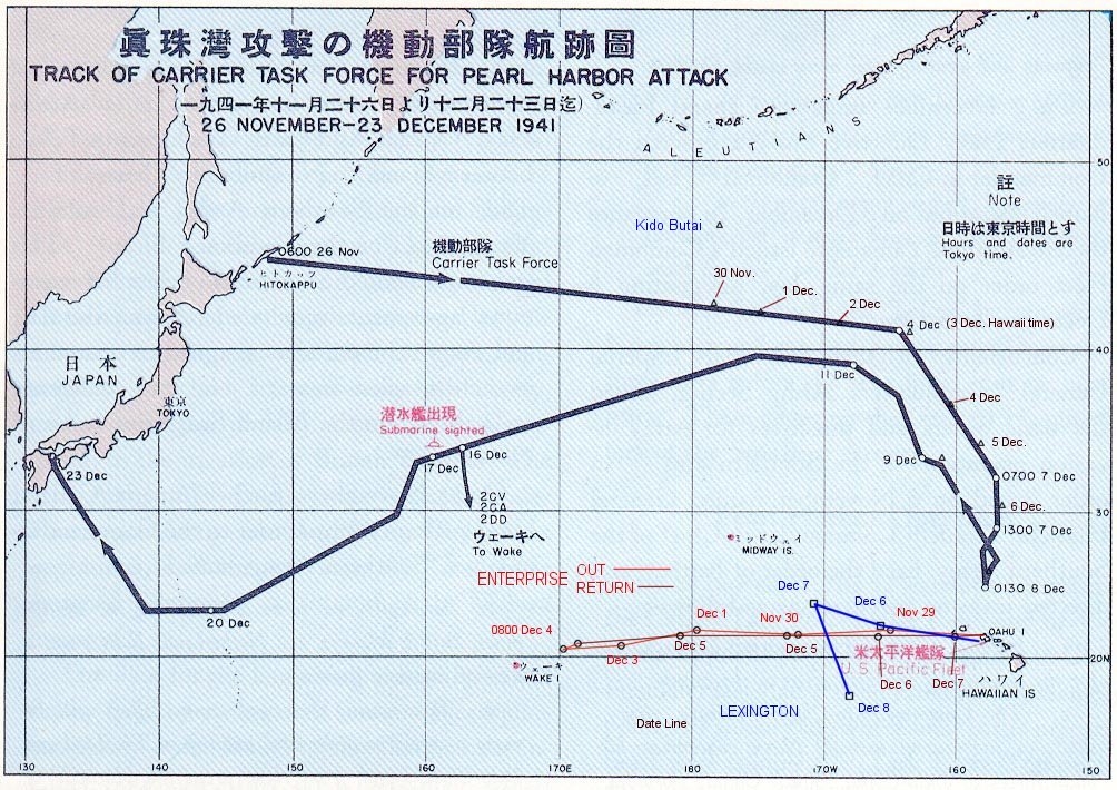
- English: The route of the Japanese flotilla (Kido Butai), with the USS Enterprise (in red) and the USS Lexington (in blue) to the South.
- Public Domain chart from "Reports of General MacArthur, prepared by his General Staff." This book was printed by GPO. The chart shows the routes of the Japanese attack force to and from Pearl Harbor. I have added the routes of the two American carriers.
+ pochází z Wikimedia Commons, kde má status – This work is in the public domain in the United States because it is a work prepared by an officer or employee of the United States Government as part of that person’s official duties under the terms of Title 17, Chapter 1, Section 105 of the US Code.
(This only applies to original works of the Federal Government and not to the work of any individual U.S. state, territory, commonwealth, county, municipality, or any other subdivision.)
(This only applies to original works of the Federal Government and not to the work of any individual U.S. state, territory, commonwealth, county, municipality, or any other subdivision.)
Historie souboru
Kliknutím na datum a čas se zobrazí tehdejší verze souboru.
| Datum a čas | Náhled | Rozměry | Uživatel | Komentář | |
|---|---|---|---|---|---|
| současná | 20. 8. 2013, 19:53 | | 1 004×710 (213 kB) | Sysop (diskuse | příspěvky) | (Fotografie + Sysop + pochází z Wikimedia Commons, kde má status – ) |
- Editovat tento soubor v externím programu (Více informací najdete v nápovědě pro nastavení.)
Odkazy na soubor
Na soubor odkazuje tato stránka:


