V pátek 26. dubna 2024 úderem 22 hodiny začíná naše nová
a opravdu velká série soutěží o nejlepší webovou stránku !!
Proto neváhejte a začněte hned zítra soutěžit o lákavé ceny !!
a opravdu velká série soutěží o nejlepší webovou stránku !!
Proto neváhejte a začněte hned zítra soutěžit o lákavé ceny !!
Soubor:1870 Baur and Bromme Map of the World on Mercator Projection - Geographicus - NeuesteKartederErde-baur-1870.jpg
Z Multimediaexpo.cz
Velikost tohoto náhledu je: 789 × 599 pixelů
Obrázek ve vyšším rozlišení (rozměr: 6 000 × 4 557 pixelů, velikost souboru: 7,51 MB, MIME typ: image/jpeg)
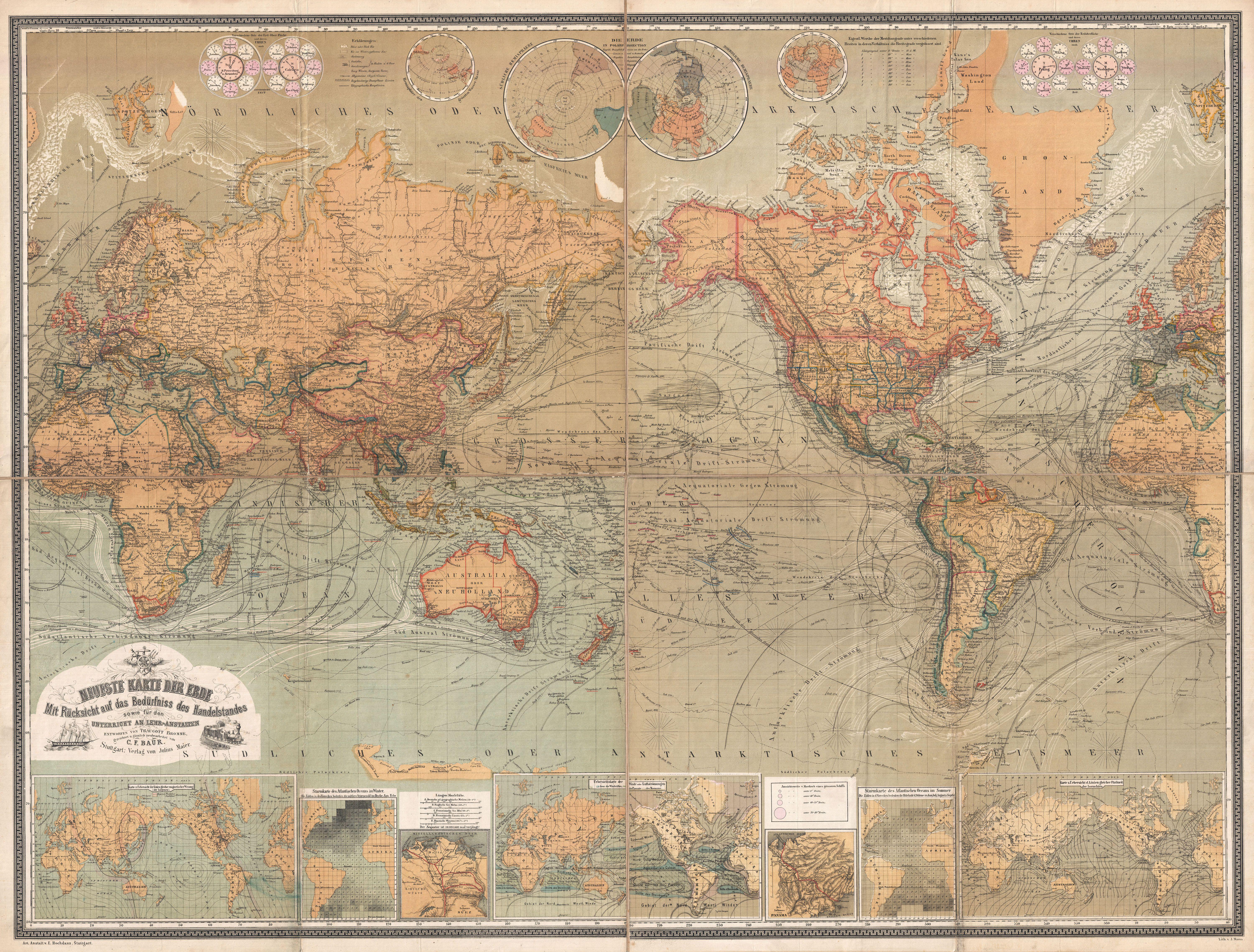
Globální mapa + Neueste Karte Der Erde Mit Rücksicht auf das Bedürfniss des Handelstandes sowie fur den Unterricht an Lehr-Anstalten.
- English: A vastly complex and enormously proportioned c. 1870 German map of the world by C. F. Baur and Traugott Bromme. Printed in c. 1870 in a multi-toned lithographic process this extraordinary map presents the world on a Mercator Projections. Designed with a educational purposes in mind, Baur manages to incorporate a staggering wealth of informative detail into ever corner of this map. The world is depicted according to the political conventions of the late 19th century. While most of the world had been explored by the late 19th century, this map does offer some interesting speculative land masses in the Arctic including Gillis Land (named after a c. 1707 whaler who supposedly spotted it) and a mysterious land mass to the northwest of the Behring Strait. The Canadian Arctic is remarkable well mapped though the whole region is shows to be locked down in glacial ice. In contrast Antarctic exploration was still in its infancy, though parts of the Antarctic coast line are noted to the south of Australia and off the coast of Tierra del Fuego. Throughout there is an attempt to map currents and wind patterns. Various explorers routes, including Cook, Biscoe, Tasman, Wilkes, Vancouver, the Resolution, Wallis, Boupet, Diego Alvarez, Bligh, Boulton, and many others. This also identifies the Saragasso Sea and another similar vortex in the Pacific. The border regions of the map are occupied by a series of smaller maps and charts including polar projections, an isothermal chart, a winds chart, an inset of Panama and Suez, two weather charts, and a magnetic variation chart. The title cartouche, appearing in the lower left quadrant shows a shop and a train as well as curious logo that seems to embraced the realms of navigation and science.
- Date: 1870 (undated)
- Dimensions – Height: 36 in (91.4 cm). Width: 49 in (124.5 cm).
+ pochází z Wikimedia Commons, kde má status – This image is in the public domain because its copyright has expired.
Historie souboru
Kliknutím na datum a čas se zobrazí tehdejší verze souboru.
| Datum a čas | Náhled | Rozměry | Uživatel | Komentář | |
|---|---|---|---|---|---|
| současná | 29. 4. 2014, 21:06 | | 6 000×4 557 (7,51 MB) | Sysop (diskuse | příspěvky) | (Globální mapa + + pochází z Wikimedia Commons, kde má status – Kategorie:PD fotografie Kategorie:Maps showing history Kategorie:Mapy světa JPG ) |
- Editovat tento soubor v externím programu (Více informací najdete v nápovědě pro nastavení.)
Odkazy na soubor
Na tento soubor neodkazuje žádná stránka.


