V encyklopedii Allmultimedia.cz byl aktivován špičkový grafický skin Foreground.
Foreground plně podporuje – RWD, HTML 5.0, Super Galerii a YouTube 2.0 !
Foreground plně podporuje – RWD, HTML 5.0, Super Galerii a YouTube 2.0 !
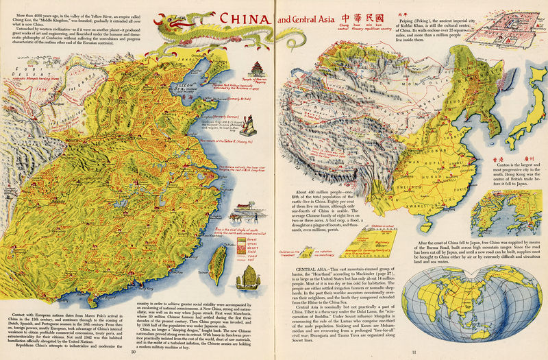
Soubor:1941 China and Central Asia.jpg
Z Multimediaexpo.cz

Velikost tohoto náhledu je: 800 × 525 pixelů
Obrázek ve vyšším rozlišení (rozměr: 9 381 × 6 161 pixelů, velikost souboru: 16,57 MB, MIME typ: image/jpeg)
GIGANTICKÁ Fotografie + English: China And Central Asia, drawn by Erwin Raisz. 34x49cm.
- Publisher': Global Press Corp. New York.
- Full color shaded relief map. Relief shown pictorially. Including text, showing circuitous land and sea routes to Free China during the pinnacle times of World War II. The cartographer Erwin Raisz has perfected a unique style of hand drawn maps that was a great contribution to 20th century cartography. More information about him may be found at [www.raiszmaps.com]
- From Atlas Of Global Geography
- Date: 1944
- Source: David Rumsey Map Collection, list no 0744.018
- Author: Erwin Raisz
+ pochází z Wikimedia Commons, kde má status – Creative Commons Attribution-Share Alike 3.0 Unported license.
Historie souboru
Kliknutím na datum a čas se zobrazí tehdejší verze souboru.
| Datum a čas | Náhled | Rozměry | Uživatel | Komentář | |
|---|---|---|---|---|---|
| současná | 5. 12. 2014, 10:44 |  | 9 381×6 161 (16,57 MB) | Sysop (diskuse | příspěvky) | (Fotografie+50) |
- Editovat tento soubor v externím programu (Více informací najdete v nápovědě pro nastavení.)
Odkazy na soubor
Na tento soubor neodkazuje žádná stránka.
