The English encyclopedia Allmultimedia.org will be launched in two phases.
The final launch of the Allmultimedia.org will take place on February 24, 2026
(shortly after the 2026 Winter Olympics).
Dovolená : 23. prosinec 2025 — 29. prosinec 2025
Holidays : December 23, 2025 — December 29, 2025
The final launch of the Allmultimedia.org will take place on February 24, 2026
(shortly after the 2026 Winter Olympics).
Dovolená : 23. prosinec 2025 — 29. prosinec 2025
Holidays : December 23, 2025 — December 29, 2025
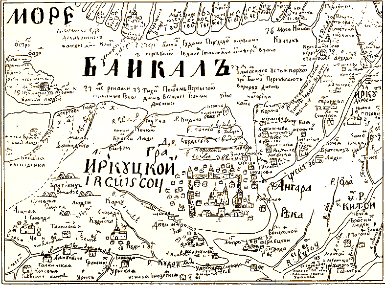
Soubor:Baikal sea.png
Z Multimediaexpo.cz
Větší rozlišení není k dispozici.
Baikal_sea.png (rozměr: 787 × 583 pixelů, velikost souboru: 81 kB, MIME typ: image/png)
Fotografie + Description:
- English: Ancient schematic map by S. U. Remizov dated 1699–1701 of Irkutsk city and the nearby territories (not in scale and distorted: Lake Baikal is drawn much smaller. North is in the bottom of the map. All the signs are in old Russian orthography, but easily recognizable for Russians (the difference: «Байкалъ» – «Байкал», «Градъ Иркуцкой» – «Город Иркутский», «Ангара рѣка» – «Ангара река»). Lake Baikal is called «Baikal Sea» («Море Байкалъ»). Scanned image, sourse
- Русский: Старинная схема Иркутска и окрестностей, сделанная в 1699—1701 годах С. У. Ремизовым. Не в масштабе: Байкал сильно уменьшен. Север находится внизу карты. Источник
- Source: www.baikal.ru
- Author: This file is lacking author information.
+ pochází z Wikimedia Commons, kde má status – This work is in the public domain in its country of origin and other countries and areas where the copyright term is the author's life plus 100 years or less.
Historie souboru
Kliknutím na datum a čas se zobrazí tehdejší verze souboru.
| Datum a čas | Náhled | Rozměry | Uživatel | Komentář | |
|---|---|---|---|---|---|
| současná | 1. 4. 2013, 14:37 | | 787×583 (81 kB) | Sysop (diskuse | příspěvky) | (BUNDESA115) |
- Editovat tento soubor v externím programu (Více informací najdete v nápovědě pro nastavení.)
Odkazy na soubor
Na soubor odkazuje tato stránka:


