
Soubor:Egypt-region-map-cities.gif
Z Multimediaexpo.cz
Mapa + Description: Regional map of Egypt, with main cities and oasis areas labeled, plus scale of miles/km (approximate). The file is in GIF format, 10x times faster than PNG format, for rapid display and to allow precise edits when adding other towns in the future.
- Re-labeled to include 6 oasis areas, with "Giza" and sea-side towns, plus dotted line for Tropic of Cancer.
- Date:
- Author: original: CIA
+ pochází z Wikimedia Commons, kde má status – This work is in the public domain in the United States because it is a work prepared by an officer or employee of the United States Government as part of that person’s official duties under the terms of Title 17, Chapter 1, Section 105 of the US Code.
Historie souboru
Kliknutím na datum a čas se zobrazí tehdejší verze souboru.
| Datum a čas | Náhled | Rozměry | Uživatel | Komentář | |
|---|---|---|---|---|---|
| současná | 14. 9. 2016, 17:56 | 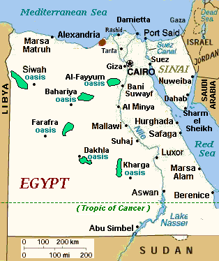 | 314×374 (17 kB) | Sysop (diskuse | příspěvky) | (Fotografie + + pochází z Wikimedia Commons, kde má status – Kategorie:CC fotografie ) |
- Editovat tento soubor v externím programu (Více informací najdete v nápovědě pro nastavení.)


