V encyklopedii Allmultimedia.cz byl aktivován špičkový grafický skin Foreground.
Foreground plně podporuje – RWD, HTML 5.0, Super Galerii a YouTube 2.0 !
Foreground plně podporuje – RWD, HTML 5.0, Super Galerii a YouTube 2.0 !
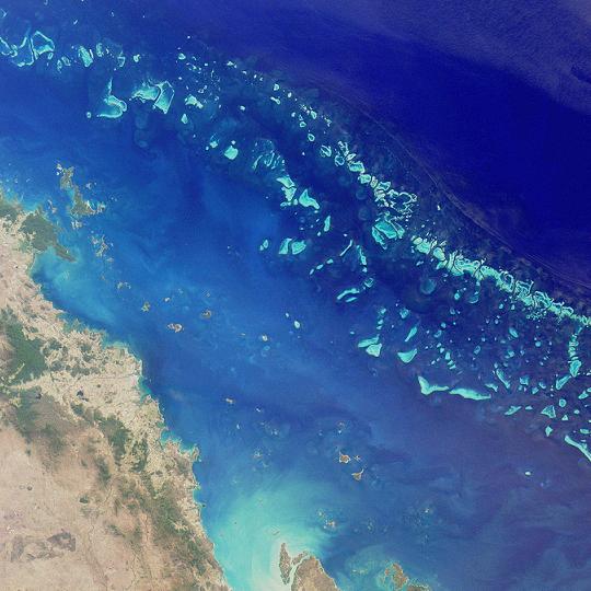
Soubor:GreatBarrierReef-EO.JPG
Z Multimediaexpo.cz
Větší rozlišení není k dispozici.
GreatBarrierReef-EO.JPG (rozměr: 540 × 540 pixelů, velikost souboru: 50 kB, MIME typ: image/jpeg)
Fotografie + Description:
- Deutsch: Satellitenfoto eines Teils des Great Barrier Reef nordöstlich von Australien. Es hat eine Länge von gut 2300 Kilometern und erreicht damit eine Ausdehnung vom 10. bis zum 24. südlichen Breitengrad. Hier ein Ausschnitt der Southern Section (auch Mackay Capricorn Reef). Östlich der Stadt Mackay im Bundesstaat Queensland. Es ist der nördliche Abschnitt der Sektion, der in die Central Section (auch Whitsunday Section) übergeht (bzw. vice versa). Der Bildausschnitt umfasst ca. 200×200 km.
- English: Satelite image of the Great Barrier Reef
- Suomi: Satellittikuva Isosta valliriutasta
- Français : Image satellite d'une partie de la grande barrière de corail (NASA)
- Italiano: Immagine satellitare di una parte della Grande barriera corallina (foto NASA)
- Polski: Wielka Rafa Koralowa - zdjęcie satelitarne
- Русский: Участок Большого барьерного рифа — вид из космоса
- Svenska: Satellitbild av Stora barriärrevet
- Date: 26 August 2000
- Source: probably http://photojournal.jpl.nasa.gov/catalog/pia03401
- Author: NASA, by MISR
+ pochází z Wikimedia Commons, kde má status – This file is in the public domain in the United States because it was solely created by NASA.
NASA copyright policy states that "NASA material is not protected by copyright unless noted".
(Use of NASA logos, insignia and emblems is restricted per U.S. law 14 CFR 1221)
NASA copyright policy states that "NASA material is not protected by copyright unless noted".
(Use of NASA logos, insignia and emblems is restricted per U.S. law 14 CFR 1221)
Historie souboru
Kliknutím na datum a čas se zobrazí tehdejší verze souboru.
| Datum a čas | Náhled | Rozměry | Uživatel | Komentář | |
|---|---|---|---|---|---|
| současná | 23. 3. 2014, 10:26 | | 540×540 (50 kB) | Student85 (diskuse | příspěvky) | (MW115FOTO) |
- Editovat tento soubor v externím programu (Více informací najdete v nápovědě pro nastavení.)
Odkazy na soubor
Na soubor odkazují tyto 2 stránky:


