Foreground plně podporuje – RWD, HTML 5.0, Super Galerii a YouTube 2.0 !
Soubor:Grossglockner from SW.jpg
Z Multimediaexpo.cz
Velikost tohoto náhledu je: 800 × 600 pixelů
Obrázek ve vyšším rozlišení (rozměr: 1 884 × 1 413 pixelů, velikost souboru: 421 kB, MIME typ: image/jpeg)
Fotografie + Description:
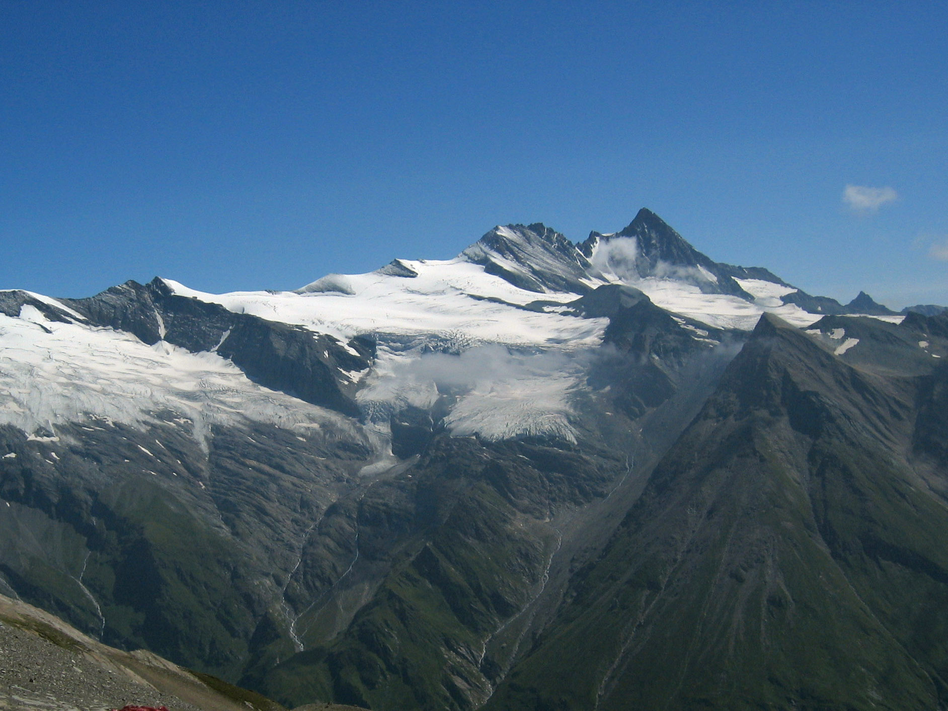
- Deutsch: Grossglockner vom Südwesten. Der Großglockner (3.797 m) ist der höchste pyramidenförmig erscheinende Gipfel rechts von der Mitte. Der breite großteils schneefreie Berg links davon ist die Glocknerwand und Hoffmannsspitze (3.722 m). Links im Bild ist über einer Felswand (Romariswand) der
Romariswandkopf (3.511 m) zu sehen. Der pyramidenförmige Berg im Vordergrund, vor dem Großglockner, ist die Zollspitze (3.024 m). Der Gletscher vor dem Großglockner ist das Teischnitzkees; rechts oberhalb der Romariswand ist das Fuschnitzkees.
Aufnahmeort: Am Silesia Höhenweg, nahe dem Sattel nördlich des Gradötzkogel aufgenommen, in ca. 2.800 m Höhe und in 8 km Entfernung vom Gipfel des Großglockners.
- English: Großglockner seen from the southwest. The Großglockner (3.797 m), the highest peak of Austria, is the highest peak in the image, pyramid-shaped, right of the center. Left of it, the more elongated and mostly snow-free mountain is the Glocknerwand and Hoffmannspitze (3.722 m). The Romariswandkopf (3.511 m) is the peak of the rock wall (Romariswand) in the left part of the image. The pyramid-shaped peak in front of the Großglockner is the Zollspitze (3.024 m).
The glacier in front of the Großglockner is the Teischnitzkees, that behind and right of the Romariswand is the Fruschnitzkees. The image was taken from approx. 2.800 m above sea level, near the saddle north of the Gradötzkogel, at the trekking route Silesia Höhenweg. The distance from the peak of the Großglockner was 8 km.
- Français : Le Grossglockner vu du sud-ouest. Le Grossglockner (3797 m), est le plus haut sommet d'Autriche. La montage plus allongée et presque libre de neige à sa gauche porte le Glocknerwand et le Hoffmannspitze (3722 m). Tout à gauche, le Romariswandkopf ("Pic du mur de pierre", 3511 m) est visible. Le sommet en forme de pyramide devant le Grossglockner s'appelle Zollspitze (3024 m).
Le glacier visible devant le Grossglockner est le Teischnitzkees, celui se trouvant en arrière et à droite du Romariswand, le Fruschnitzkees. Photo prise à 8 km de distance, depuis un collet au nord du Gradötzkogel, sur le chemin Silesia Höhenweg, à 2800 m d'altitude.
- Date: 30 July 2003
- Source: Photo taken by myself, cropped, color balance slightly adjusted.
- Author: Michael Schmid
+ pochází z Wikimedia Commons, kde má status – This file is licensed under the Creative Commons Attribution-Share Alike 2.0 Austria license.
Historie souboru
Kliknutím na datum a čas se zobrazí tehdejší verze souboru.
| Datum a čas | Náhled | Rozměry | Uživatel | Komentář | |
|---|---|---|---|---|---|
| současná | 29. 3. 2014, 12:10 | | 1 884×1 413 (421 kB) | Ulysses (diskuse | příspěvky) | (MW1.15-Fotografie) |
- Editovat tento soubor v externím programu (Více informací najdete v nápovědě pro nastavení.)
Odkazy na soubor
Na soubor odkazují tyto 2 stránky:


