V encyklopedii Allmultimedia.cz byl aktivován špičkový grafický skin Foreground.
Foreground plně podporuje – RWD, HTML 5.0, Super Galerii a YouTube 2.0 !
Foreground plně podporuje – RWD, HTML 5.0, Super Galerii a YouTube 2.0 !
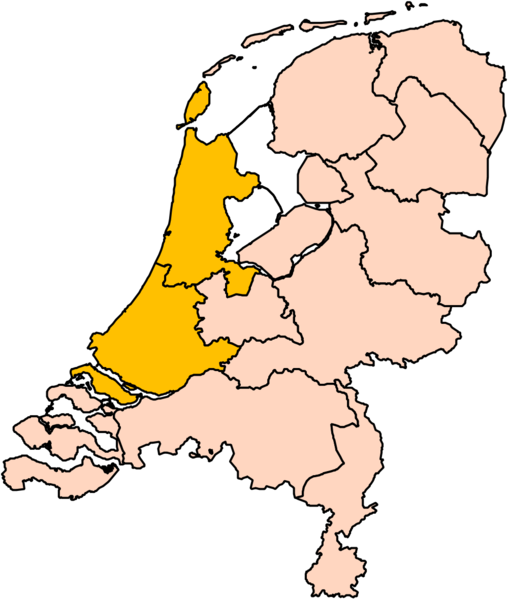
Soubor:Holland position.png
Z Multimediaexpo.cz

Velikost tohoto náhledu je: 508 × 599 pixelů
Obrázek ve vyšším rozlišení (rozměr: 1 000 × 1 180 pixelů, velikost souboru: 140 kB, MIME typ: image/png)
Mapa + English: edit to User:Mtcv's Image:Noord-Holland position.svg to show North and South Holland together.
- This image is (in part or entirely) based on geographical data from Statistics Netherlands (Centraal Bureau voor de Statistiek). Digital geometry files in ESRI format can be downloaded from their website.
- Author: User:Mtcv , Roke~commonswiki
+ pochází z Wikimedia Commons, kde má status – The copyright holder of this file, Centraal Bureau voor de Statistiek, allows anyone to use it for any purpose, provided that the copyright holder is properly attributed. Redistribution, derivative work, commercial use, and all other use is permitted.
Historie souboru
Kliknutím na datum a čas se zobrazí tehdejší verze souboru.
| Datum a čas | Náhled | Rozměry | Uživatel | Komentář | |
|---|---|---|---|---|---|
| současná | 12. 2. 2017, 00:08 |  | 1 000×1 180 (140 kB) | Sysop (diskuse | příspěvky) | (Fotografie + + pochází z Wikimedia Commons, kde má status – Kategorie:CC fotografie) |
- Editovat tento soubor v externím programu (Více informací najdete v nápovědě pro nastavení.)
Odkazy na soubor
Na soubor odkazuje tato stránka:
