Foreground plně podporuje – RWD, HTML 5.0, Super Galerii a YouTube 2.0 !
Soubor:Hurricane katrina damage gulfport mississippi.jpg
Z Multimediaexpo.cz
Velikost tohoto náhledu je: 800 × 532 pixelů
Obrázek ve vyšším rozlišení (rozměr: 3 008 × 2 000 pixelů, velikost souboru: 2,64 MB, MIME typ: image/jpeg)
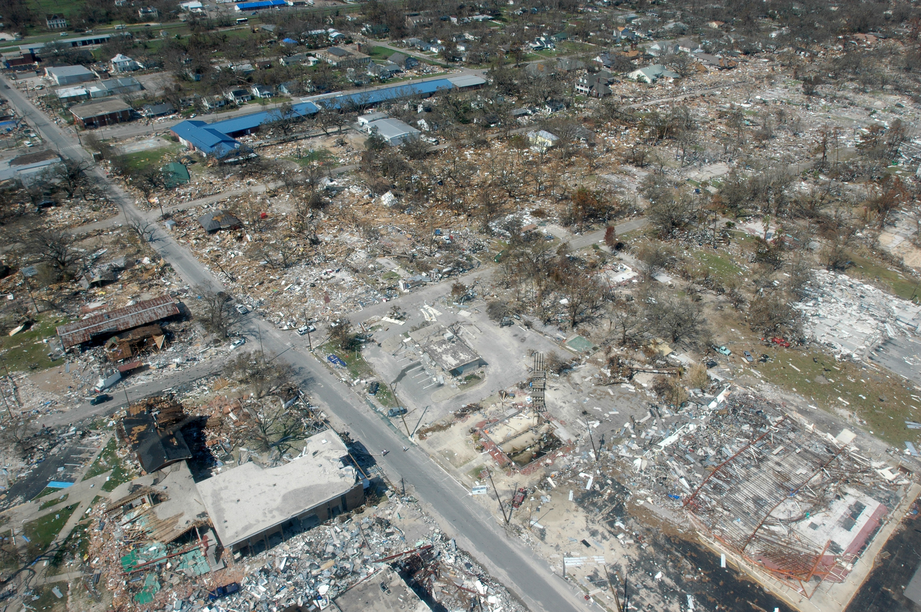
Fotografie + Gulfport, Miss., September 6, 2005 -- Destroyed houses in Gulfport, Miss. Hurricane Katrina caused extensive damage all along the Mississippi gulf coast. FEMA/Mark Wolfe
Hurricane Katrina damage in Long Beach, Mississippi, which is west of Gulfport and east of Pass Christian. Picture taken looking north on Jeff Davis Avenue. Long blue building to the right is Harper McCaughan Elementary School, which appears to be shifted off of its foundation. To the north of that is Long Beach Public Library, with Long Beach City Hall to the north of the library. Although these building appear to be standing, upon closer inspection, they were heavily damaged.
The east-west streets showing are (going north) 5th St, 4th St, and 3rd St (school and library intersection), 2nd St, then a little of the railroad tracks. There used to be as many houses on 4th and 5th streets as on 3rd St, and all used to have a heavy cover of trees. The picture shows a small portion of these streets, but the damaged area extends for several miles to the east and to the west. To the south of the picture (but not showing) is the beach and Highway 90.
The debris piles don't show very much in this photo, but they were at least 10 - 15 ft high in some places along 4th St. You can see it better if you notice the debris line in relation to some of the houses, which is to the roof tops on some houses.
The section of Long Beach north of the railroad tracks is making a very speedy recovery, thanks to the diligence of City workers and all of the many volunteers in the area. The outpouring of support from all over the country has been incredible and greatly appreciated.
The section of Long Beach south of the tracks is a different story, although debris removal is coming along and a very few people have moved back into their homes. All (but one) of the people on Highway 90 lost their homes completely (gone with no trace), almost all on 5th and 4th streets have lost their homes completely, and most of the homes on 2nd and 3rd streets are heavily damaged, either by wind or by water. Most did not have flood insurance, except on Highway 90.
+ pochází z Wikimedia Commons, kde má status -- Public domain (This image is a work of a Federal Emergency Management Agency).
Historie souboru
Kliknutím na datum a čas se zobrazí tehdejší verze souboru.
| Datum a čas | Náhled | Rozměry | Uživatel | Komentář | |
|---|---|---|---|---|---|
| současná | 21. 5. 2013, 17:27 | | 3 008×2 000 (2,64 MB) | Sysop (diskuse | příspěvky) | (FILE1122) |
- Editovat tento soubor v externím programu (Více informací najdete v nápovědě pro nastavení.)
Odkazy na soubor
Na soubor odkazuje tato stránka:


