Soubor:Isle of Man topographic map-en.png
Z Multimediaexpo.cz
Velikost tohoto náhledu je: 654 × 600 pixelů
Obrázek ve vyšším rozlišení (rozměr: 1 000 × 917 pixelů, velikost souboru: 425 kB, MIME typ: image/png)
Mapa + Description:
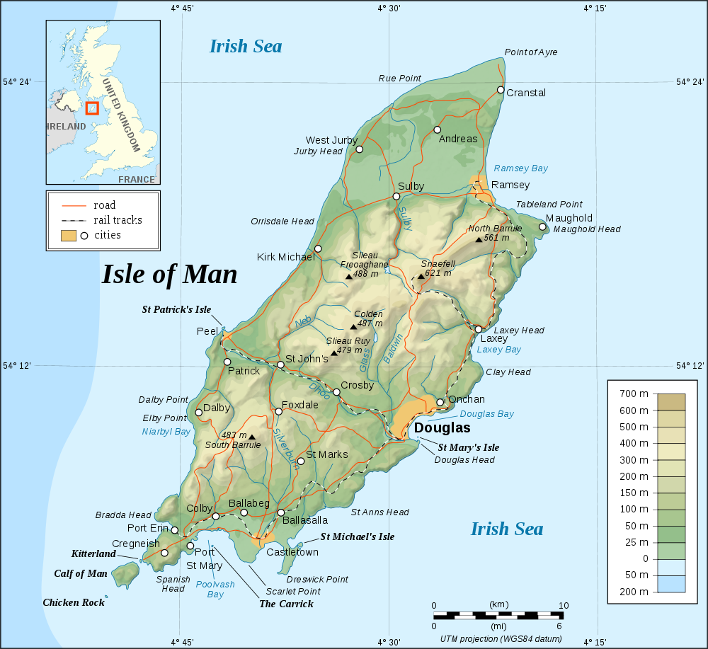
- English: Topographic map in English of the Isle of Man.
- Note : The shaded relief is a raster image embedded in the SVG.
- Français: Carte topographique en anglais de l'Île de Man.
- Note : Le relief ombré est une image bitmap embarquée dans le fichier SVG.
- Português: Mapa topográfico (em Inglês) da Ilha de Man.
- Русский: Топографическая карта Острова Мэн на английском языке
- UTM projection; WGS84 datum; shaded relief (composite image of N-W, W and N lightning positions);
- Approximate scale of topographic data and shore / lakes limits: 1:372,000 (precision: 93 m)
- Date: May 2007
- Source: Topographic map: NASA Shuttle Radar Topography Mission (SRTM3 v.2) (public domain) edited with 3DEM from Visualization Software LLC and vectorized with Inkscape;
- NASA World Wind;
- UK Genealogy map;
- Microsoft Encarta atlas (1999 edition);
- Author: Eric Gaba (Sting)
+ pochází z Wikimedia Commons, kde má status – This file is licensed under the Creative Commons Attribution-Share Alike 2.5 Generic, 2.0 Generic and 1.0 Generic license.
Historie souboru
Kliknutím na datum a čas se zobrazí tehdejší verze souboru.
| Datum a čas | Náhled | Rozměry | Uživatel | Komentář | |
|---|---|---|---|---|---|
| současná | 14. 5. 2013, 21:03 | | 1 000×917 (425 kB) | Sysop (diskuse | příspěvky) | (Mapa + + pochází z Wikimedia Commons, kde má status – Creative Commons Attribution-Share Alike 3.0 Unported (autor: TUBS). Kategorie:CC fotografie Kategorie:Mapy světa PNG) |
- Editovat tento soubor v externím programu (Více informací najdete v nápovědě pro nastavení.)
Odkazy na soubor
Na soubor odkazuje tato stránka:


