The English encyclopedia Allmultimedia.org will be launched in two phases.
The final launch of the Allmultimedia.org will take place on February 24, 2026
(shortly after the 2026 Winter Olympics).
Dovolená : 23. prosinec 2025 — 29. prosinec 2025
Holidays : December 23, 2025 — December 29, 2025
The final launch of the Allmultimedia.org will take place on February 24, 2026
(shortly after the 2026 Winter Olympics).
Dovolená : 23. prosinec 2025 — 29. prosinec 2025
Holidays : December 23, 2025 — December 29, 2025
Soubor:Limes2.png
Z Multimediaexpo.cz
Velikost tohoto náhledu je: 580 × 600 pixelů
Obrázek ve vyšším rozlišení (rozměr: 2 946 × 3 046 pixelů, velikost souboru: 2,74 MB, MIME typ: image/png)
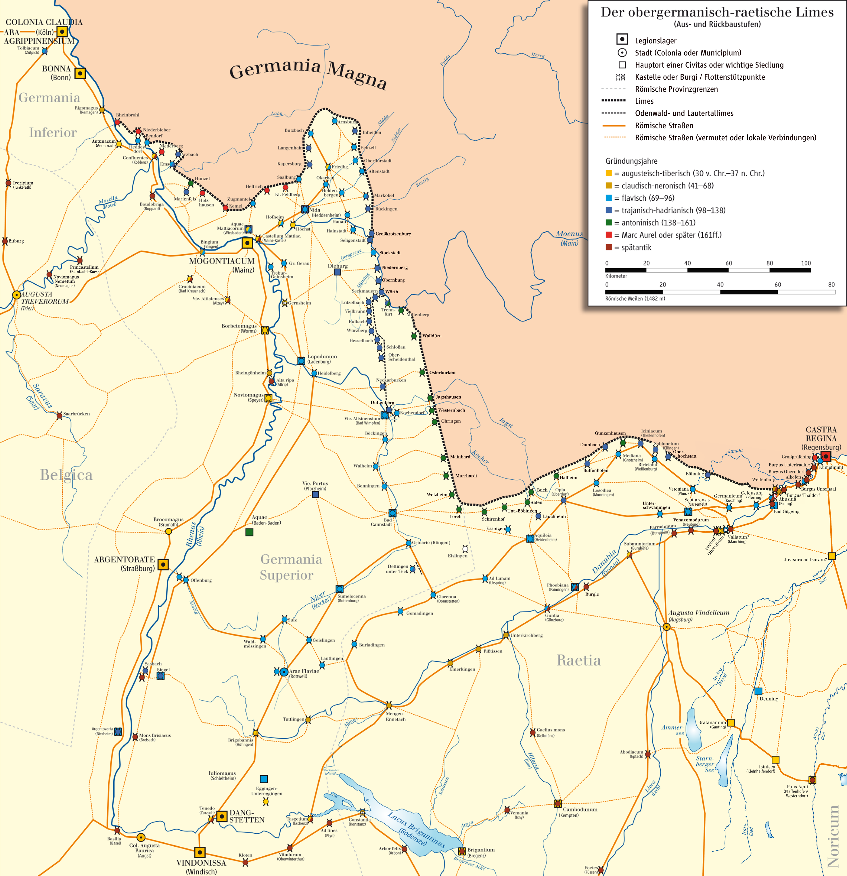
Mapa + English: Map of Limes Germanicus (system of fortifications representing the boundary of Roman control in the Rhine-Danube angle)
- Deutsch: Karte des Obergermanisch-raetischen Limes
- Date: 18 December 2008
- Source: own drawing/Source of Information: Putzger – Historischer Weltatlas, 89. Auflage, 1965; Westermanns Großer Atlas zur Weltgeschichte, 1978; Martin Kemkes: „Römer an Donau und Iller. Neue Forschungen und Funde.“ Thorbecke, Sigmaringen 1996, ISBN 3-7995-0410-9, S. 152f.; Dietwulf Baatz: Der Römische Limes. Archäologische Ausflüge zwischen Rhein und Donau. 4. Auflage. Gebr. Mann, Berlin 2000, ISBN 3-7861-2347-0; Thomas Fischer und Günther Ulbert: Der Limes in Bayern. Von Dinkelsbühl bis Eining. Theiss, Stuttgart 1983, ISBN 3-8062-0351-2; Heinz Cüppers: Die Römer in Rheinland-Pfalz. Lizenzausgabe. Nikol, Hamburg 2002. ISBN 3-933203-60-0; Cliff Alexander Jost: Der römische Limes in Rheinland-Pfalz. (Archäologie an Mittelrhein und Mosel, Band 14), Landesamt für Denkmalpflege Rheinland-Pfalz, Koblenz 2003, ISBN 3-929645-07-6; Dietwulf Baatz und Fritz-Rudolf Herrmann: Die Römer in Hessen. Lizenzausgabe. Nikol, Hamburg 2002, ISBN 3-933203-58-9; Dieter Planck (Hrsg.): Die Römer in Baden-Württemberg. Theiss, Stuttgart 2005, ISBN 3-8062-1555-3; Philipp Filtzinger, Dieter Planck und Bernhard Cämmerer (Hrsg.): Die Römer in Baden-Württemberg. 3. Auflage. Theiss, Stuttgart 1986, ISBN 3-8062-0287-7; Wolfgang Czysz u.a.: Die Römer in Bayern. Lizenzausgabe. Nikol, Hamburg 2005, ISBN 3-937872-11-6; Dieter Planck u.a.: Imperium Romanum. Roms Provinzen an Neckar, Rhein und Donau. Theiss, Stuttgart 2005. ISBN 978-3-8062-2140-4
- Author: ziegelbrenner
+ pochází z Wikimedia Commons, kde má status – Creative Commons Attribution-Share Alike 3.0 Unported license.
Historie souboru
Kliknutím na datum a čas se zobrazí tehdejší verze souboru.
| Datum a čas | Náhled | Rozměry | Uživatel | Komentář | |
|---|---|---|---|---|---|
| současná | 14. 7. 2015, 09:32 | | 2 946×3 046 (2,74 MB) | Ivan Drago (diskuse | příspěvky) | (Mapa + English: Map of Limes Germanicus (system of fortifications representing the boundary of Roman control in the Rhine-Danube angle) * Deutsch: Karte des Obergermanisch-raetischen Limes * Date: 18 December 2008 * Source: own drawing/Source of Informati) |
- Editovat tento soubor v externím programu (Více informací najdete v nápovědě pro nastavení.)
Odkazy na soubor
Na soubor odkazuje tato stránka:


