V encyklopedii Allmultimedia.cz byl aktivován špičkový grafický skin Foreground.
Foreground plně podporuje – RWD, HTML 5.0, Super Galerii a YouTube 2.0 !
Foreground plně podporuje – RWD, HTML 5.0, Super Galerii a YouTube 2.0 !
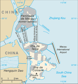
Soubor:Macau-CIA WFB Map.png
Z Multimediaexpo.cz
Větší rozlišení není k dispozici.
Macau-CIA_WFB_Map.png (rozměr: 328 × 352 pixelů, velikost souboru: 20 kB, MIME typ: image/png)
Mapa + English: This map represents the Special Administrative Region of Macau of the People's Republic of China, formed by the Peninsula of Macau and the islands of Taipa and Coloane.
+ pochází z Wikimedia Commons, kde má status – This image is in the public domain because it contains materials that originally came from the United States Central Intelligence Agency's World Factbook.
Historie souboru
Kliknutím na datum a čas se zobrazí tehdejší verze souboru.
| Datum a čas | Náhled | Rozměry | Uživatel | Komentář | |
|---|---|---|---|---|---|
| současná | 10. 4. 2014, 11:00 | | 328×352 (20 kB) | Sysop (diskuse | příspěvky) | (MW1.15-Fotografie) |
- Editovat tento soubor v externím programu (Více informací najdete v nápovědě pro nastavení.)
Odkazy na soubor
Na soubor odkazuje tato stránka:


