
Soubor:Map Greece expansion 1832-1947-cs-2.png
Z Multimediaexpo.cz
Velikost tohoto náhledu je: 457 × 599 pixelů
Obrázek ve vyšším rozlišení (rozměr: 960 × 1 259 pixelů, velikost souboru: 304 kB, MIME typ: image/png)
Mapa + Description:
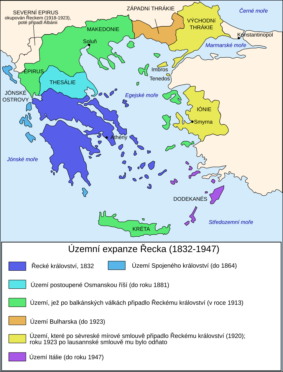
- Čeština: Mapa zobrazuje územní expanzi Řeckého království (1832–1947).
- Dansk: Kort over Grækenlands territoriale udvidelser, 1832-1947.
- Deutsch: Territoriale Expansion Griechenlands 1832-1947.
- English: The territorial expansion of Greece, 1832-1947.
- Español: Mapa de la expansión territorial griega (1832-1947)
- Euskara: Greziaren lurralde hedapena 1832-1947 bitartean
- Français : L'expansion territoriale de la Grèce. 1832-1947.
- Hrvatski: Teritorijalno proširenje Grčke u razdoblju od 1832. do 1947.
- Italiano: L'espansione territoriale della Grecia dal 1832 al 1947
- Magyar: Görögország területi növekedése (1832-1947)
- Occitan : Evolucions territòrialas de Grècia.
- Svenska: Greklands territoriella utveckling (1832–1947)
- Ελληνικά: Η εδαφική επέκταση της Ελλάδας 1832-1947.
- Македонски: Територијално проширување на Грција
- 日本語: ギリシャ王国の版図拡大 (1832-1947年)
- 中文: 希腊的领土变迁,1832年-1947年间。
- Author: Historicair
- translator Rursus, Podzemnik, en:User:Adam Carr
+ pochází z Wikimedia Commons, kde má status – Permission is granted to copy, distribute and/or modify this document under the terms of the GNU Free Documentation License, Version 1.2 or any later version published by the Free Software Foundation; with no Invariant Sections, no Front-Cover Texts, and no Back-Cover Texts.
Historie souboru
Kliknutím na datum a čas se zobrazí tehdejší verze souboru.
| Datum a čas | Náhled | Rozměry | Uživatel | Komentář | |
|---|---|---|---|---|---|
| současná | 13. 7. 2026, 16:46 | | 960×1 259 (304 kB) | Sysop (diskuse | příspěvky) | (Fotografie + ) |
- Editovat tento soubor v externím programu (Více informací najdete v nápovědě pro nastavení.)
Odkazy na soubor
Na soubor odkazuje tato stránka:


