V pátek 26. dubna 2024 úderem 22 hodiny začíná naše nová
a opravdu velká série soutěží o nejlepší webovou stránku !!
Proto neváhejte a začněte hned zítra soutěžit o lákavé ceny !!
a opravdu velká série soutěží o nejlepší webovou stránku !!
Proto neváhejte a začněte hned zítra soutěžit o lákavé ceny !!
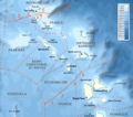
Soubor:Maritime boundaries between UK and France in Antilles-fr.png
Z Multimediaexpo.cz

Velikost tohoto náhledu je: 676 × 599 pixelů
Obrázek ve vyšším rozlišení (rozměr: 1 502 × 1 332 pixelů, velikost souboru: 773 kB, MIME typ: image/png)
Mapa + Description:
- English: Maritime boundaries between UK and France in Antilles.
- Français : Frontières maritimes entre la France et le Royaume-Uni aux Antilles
- Date: 15 March 2013, 22:04 (UTC)
- Source:
- English:
- Shorelines, lakes, rivers, borders: NGDC GSHHS
- Relief: National Geophysical Data Center (NGDC) ETOPO1
- Projection: Lambert Conformal Conic, First standard parallel: 16, Second standard parallel: 18, Central meridian : -62.25
- N 18.5, W -64, S 15.5, E -60.5
- Français : Sources :
- Côtes, lacs, rivières, frontières : NGDC GSHHS
- Relief : Centre de données géophysiques nationales (NGDC) ETOPO1
- Projection conique conforme de Lambert, premier parallèle standard : 16, second parallèle standard : 18, méridien central : -62.25
- N 18.5, O -64, S 15.5, E -60.5
- English:
- Author: Sémhur
+ pochází z Wikimedia Commons, kde má status – This file is licensed under the Creative Commons Attribution-Share Alike 4.0 International, 3.0 Unported, 2.5 Generic, 2.0 Generic and 1.0 Generic license.
Historie souboru
Kliknutím na datum a čas se zobrazí tehdejší verze souboru.
| Datum a čas | Náhled | Rozměry | Uživatel | Komentář | |
|---|---|---|---|---|---|
| současná | 19. 7. 2022, 16:26 |  | 1 502×1 332 (773 kB) | Sysop (diskuse | příspěvky) | (Fotografie + ) |
- Editovat tento soubor v externím programu (Více informací najdete v nápovědě pro nastavení.)
Odkazy na soubor
Na soubor odkazuje tato stránka:
