V encyklopedii Allmultimedia.cz byl aktivován špičkový grafický skin Foreground.
Foreground plně podporuje – RWD, HTML 5.0, Super Galerii a YouTube 2.0 !
Foreground plně podporuje – RWD, HTML 5.0, Super Galerii a YouTube 2.0 !
Soubor:Satellite image of Cape peninsula.jpg
Z Multimediaexpo.cz
Velikost tohoto náhledu je: 800 × 504 pixelů
Obrázek ve vyšším rozlišení (rozměr: 2 184 × 1 377 pixelů, velikost souboru: 1,46 MB, MIME typ: image/jpeg)
Fotografie + Description:
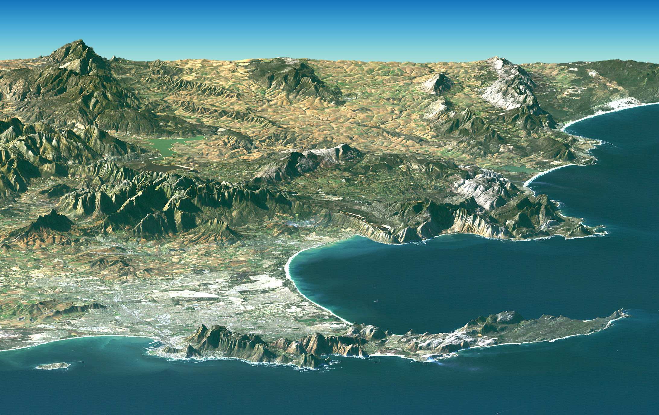
- Afrikaans: 'n Satellietbeeld van die Kaapse Skiereiland en aanliggende Wes-Kaap in Suid-Afrika wat in Februarie 2000 deur Nasa geneem is, met behulp van hul Landsat. Kaapstad en die Kaap die Goeie Hoop verskyn in die voorgrond van hierdie beeld. Die middestad is aan Tafelbaai geleë, digby Tafelberg. Tafelberg is 1 086 meter hoog en bestaan uit sandsteen en graniet. Die groot suidelike baai, wat soos 'n gat in die vasteland lyk, is Valsbaai. 'n Satellietfoto wat deur Landsat geneem is, word met data van die hoogtes bo seevlak van die betrokke gebiede (saamgestel deur die Shuttle Radar Topography Mission, of SRTM) gekombineer om hierdie saamgestelde beeld te verkry. Die foto is deur NASA geskep en die oorspronklike beeld is te vinde by hierdie skakel.
- Deutsch: Satellitenbild des Kap der Guten Hoffnung, erstellt aus Bildern von Landsat und Daten der SRT-Mission des NASA Space Shuttle Endeavor vom Februar 2000. Kapstadt und das Kap sind im Vordergrund der perspektivischen Ansicht zu sehen. Die perspektivische Ansicht wurde künstlich aus Fotografien und Radardaten zusammengesetzt.
- English: PIA04961: Cape Town, South Africa, Perspective View, Landsat Image over SRTM Elevation. Cape Town and the Cape of Good Hope, South Africa, appear in the foreground of this perspective view generated from a Landsat satellite image and elevation data from the Shuttle Radar Topography Mission (SRTM). The city center is located at Table Bay (at the lower left), adjacent to Table Mountain, a 1,086-meter (3,563-foot) tall sandstone and granite natural landmark. The large bay facing right (South) is False Bay. The perspective is computer generated, combining a photograph with elevation data collected using radar. This Landsat and SRTM perspective view uses a 2-times vertical exaggeration to enhance topographic expression. The back edges of the data sets form a false horizon and a false sky was added. Colors of the scene were enhanced by image processing but are the natural color band combination from the Landsat satellite.
- Date: February 2007
- Source: https://photojournal.jpl.nasa.gov/catalog/PIA04961
- Author: NASA
+ pochází z Wikimedia Commons, kde má status – This file is in the public domain in the United States because it was solely created by NASA.
NASA copyright policy states that "NASA material is not protected by copyright unless noted".
(Use of NASA logos, insignia and emblems is restricted per U.S. law 14 CFR 1221)
NASA copyright policy states that "NASA material is not protected by copyright unless noted".
(Use of NASA logos, insignia and emblems is restricted per U.S. law 14 CFR 1221)
Historie souboru
Kliknutím na datum a čas se zobrazí tehdejší verze souboru.
| Datum a čas | Náhled | Rozměry | Uživatel | Komentář | |
|---|---|---|---|---|---|
| současná | 19. 9. 2013, 07:37 | | 2 184×1 377 (1,46 MB) | Sysop (diskuse | příspěvky) | (Fotografie + Sysop + pochází z Wikimedia Commons, kde má status – ) |
- Editovat tento soubor v externím programu (Více informací najdete v nápovědě pro nastavení.)
Odkazy na soubor
Na soubor odkazují tyto 2 stránky:


