Foreground plně podporuje – RWD, HTML 5.0, Super Galerii a YouTube 2.0 !
Soubor:UkinrekMaars.jpg
Z Multimediaexpo.cz
Velikost tohoto náhledu je: 800 × 545 pixelů
Obrázek ve vyšším rozlišení (rozměr: 1 024 × 697 pixelů, velikost souboru: 161 kB, MIME typ: image/jpeg)
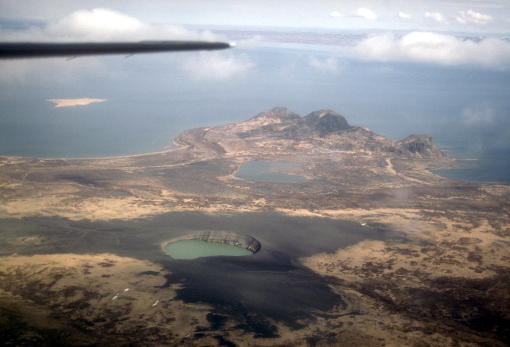
Fotografie + English: "Aerial view, looking north, over the Ukinrek Maars on the south shore of Becharof Lake on the Alaska Peninsula. The maar craters formed during a 10-day eruption in March and April of 1977. In the distance (center) are the Gas Rocks, an older volcanic center. Photograph by C. Nye, Alaska Division of Geological and Geophysical Surveys, May 9, 1994."
Lake Becharof at top of photo. Water partially fills the eastern maar and completely covers a lava dome that was erupted in the 100-m deep crater during a 10-day eruption in 1977. Maar is about 300 m in diameter.
- Date: 9 May 1994
- Source: Volcanoes of the Alaska Peninsula and Aleutian Islands-Selected Photographs - Album.
- Author: C. Nye, Alaska Division of Geological and Geophysical Surveys
+ pochází z Wikimedia Commons, kde má status – This image is in the public domain because it only contains materials that originally came from the United States Geological Survey, an agency of the United States Department of the Interior.
Historie souboru
Kliknutím na datum a čas se zobrazí tehdejší verze souboru.
| Datum a čas | Náhled | Rozměry | Uživatel | Komentář | |
|---|---|---|---|---|---|
| současná | 8. 1. 2015, 23:18 | | 1 024×697 (161 kB) | Sysop (diskuse | příspěvky) | (Fotografie + + pochází z Wikimedia Commons, kde má status – ) |
- Editovat tento soubor v externím programu (Více informací najdete v nápovědě pro nastavení.)
Odkazy na soubor
Na soubor odkazuje tato stránka:


