The English encyclopedia Allmultimedia.org will be launched in two phases.
The final launch of the Allmultimedia.org will take place on February 24, 2026
(shortly after the 2026 Winter Olympics).
Dovolená : 23. prosinec 2025 — 29. prosinec 2025
Holidays : December 23, 2025 — December 29, 2025
The final launch of the Allmultimedia.org will take place on February 24, 2026
(shortly after the 2026 Winter Olympics).
Dovolená : 23. prosinec 2025 — 29. prosinec 2025
Holidays : December 23, 2025 — December 29, 2025
Soubor:Warszawa Powstanie 1944-09-10.jpg
Z Multimediaexpo.cz
Velikost tohoto náhledu je: 483 × 600 pixelů
Obrázek ve vyšším rozlišení (rozměr: 1 600 × 1 986 pixelů, velikost souboru: 2,41 MB, MIME typ: image/jpeg)
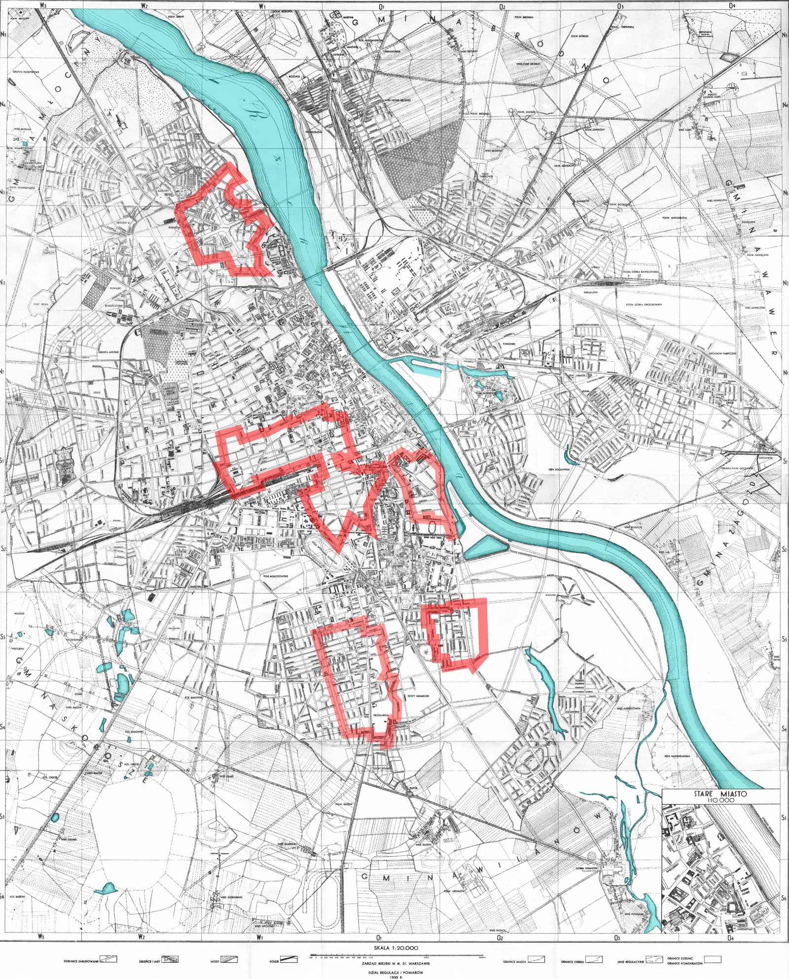
Mapa + Description: The areas of Warsaw controlled by the Home Army on September 10th, 1944, during the Warsaw Uprising.
- This map was based on a variety of sources and is pretty accurate, but don't expect any map to be any more or any less accurate: there were no stable front-lines and the ones presented here are only for orientation. Also note that not all areas outside of the Polish zone of control were controlled by the Germans.
- Date: 6 May 2007
- Source: Based on Image:Warszawa 1935.png
- Made by Halibutt in GIMP and Inkscape, basing on maps published in: Jerzy Kirchmayer (1978). Powstanie warszawskie. Warsaw: Książka i Wiedza, 576. ISBN 83-05-11080-X, and several other maps available.
- Author: Halibutt
+ pochází z Wikimedia Commons, kde má status – Permission is granted to copy, distribute and/or modify this document under the terms of the GNU Free Documentation License, Version 1.2 or any later version published by the Free Software Foundation; with no Invariant Sections, no Front-Cover Texts, and no Back-Cover Texts.
Historie souboru
Kliknutím na datum a čas se zobrazí tehdejší verze souboru.
| Datum a čas | Náhled | Rozměry | Uživatel | Komentář | |
|---|---|---|---|---|---|
| současná | 31. 10. 2014, 12:15 | | 1 600×1 986 (2,41 MB) | Sysop (diskuse | příspěvky) | (Fotografie+75) |
- Editovat tento soubor v externím programu (Více informací najdete v nápovědě pro nastavení.)
Odkazy na soubor
Na soubor odkazuje tato stránka:


