a opravdu velká série soutěží o nejlepší webovou stránku !!
Proto neváhejte a začněte hned zítra soutěžit o lákavé ceny !!
Soubor:West Bank & Gaza Map 2007 (Settlements).png
Z Multimediaexpo.cz
Velikost tohoto náhledu je: 482 × 599 pixelů
Obrázek ve vyšším rozlišení (rozměr: 780 × 970 pixelů, velikost souboru: 86 kB, MIME typ: image/png)
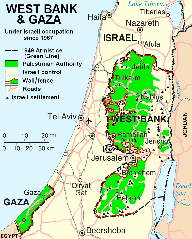
Mapa + English: This map is a modification, suggested as a replacement for, or in addition to, the one uploaded by ChrisO at which is used in the Wikipedia article "Palestine," under the History subheading Current Status. My modification shows "facts on the ground" which are essential to any understanding of the situation in Palestine today. The geographic facts are not in dispute. They have been widely published in print and on the internet.
Both my map and the ChrisO map are modifications of a 2004 United Nations map of Israel:
(public domain) in which the three Occupied Territories, the West Bank, Gaza, and Golon, are given the same brown color as Israel's neighboring countries: Egypt, Jordan, Syria, and Lebanon. ChrisO colors the West Bank, Gaza, and Golon light green and renames the map "Israel and the Occupied Territories." However Golon is Syrian, not Palestinian. For an article on Palestine, attention should be on the West Bank and Gaza.
My modification crops out Golon and the Negev desert to focus in on the West Bank and Gaza. It also incorporates information from several published sources to show the land and resources actually available to Palestinian people in these two territories, the West Bank in particular.
- Author: Scott
+ pochází z Wikimedia Commons, kde má status – I, the copyright holder of this work, release this work into the public domain. This applies worldwide.
Historie souboru
Kliknutím na datum a čas se zobrazí tehdejší verze souboru.
| Datum a čas | Náhled | Rozměry | Uživatel | Komentář | |
|---|---|---|---|---|---|
| současná | 10. 10. 2016, 14:43 | | 780×970 (86 kB) | Alastor (diskuse | příspěvky) | (Fotografie + + pochází z Wikimedia Commons, kde má status – Kategorie:CC fotografie) |
- Editovat tento soubor v externím programu (Více informací najdete v nápovědě pro nastavení.)
Odkazy na soubor
Na soubor odkazuje tato stránka:
.png&action=edit)
.png&action=history)
.png)
.png&oldid=1137328)
.png)
.png)
.png&action=edit&redlink=1)
.png&action=edit&externaledit=true&mode=file)
.png)