Dovolená : 1. květen 2026 a 8. květen 2026 (Státní svátky České republiky)
Holidays : May 1, 2026, and May 8, 2026 (Public Holidays in the Czech Republic)
Vacaciones : 1 de mayo de 2026 y 8 de mayo de 2026 (Días festivos de la República Checa)
Holidays : May 1, 2026, and May 8, 2026 (Public Holidays in the Czech Republic)
Vacaciones : 1 de mayo de 2026 y 8 de mayo de 2026 (Días festivos de la República Checa)
Soubor:Iran's Rainbow Island.jpg
Z Multimediaexpo.cz
(Rozdíly mezi verzemi)
(Fotografie +) |
(++) |
||
| Řádka 1: | Řádka 1: | ||
| - | Fotografie + | + | Fotografie + Description: |
| + | * With its colorful soils, salt caves and mountains, and ocher-stained streams and beaches, Iran’s Hormuz island is rich with memorable geology. | ||
| + | * The island is a salt dome—a teardrop-shaped mound of rock salt, gypsum, anhydrite, and other evaporites that has risen upward through overlying layers of rock. Rock salt, or halite, is weak and buoyant, so it loses its brittleness and flows more like a liquid when under high pressure. | ||
| + | * The rising mass is not purely made of salt. Embedded within it are layers of clay, carbonates, shale, and iron-rich volcanic rocks, some of which have taken on vivid shades of red, yellow, and orange as they moved upward and interacted with water and minerals from other rock layers. | ||
| + | * The concentric ring structure of the uplifted salt dome is visible in this natural-color image acquired by the Operational Land Imager (OLI) on Landsat 8. Uplifted halite is widespread near the central and southern two-thirds of the island, which appear reddish amid outcrops of weathered, volcanic rocks that appear gray. The tan northern third of the island is covered by a layer of sand and other sediment that was deposited by other processes. | ||
| + | * The ocher soils on the island have proven appealing to cooks, artists, and miners alike. Locals reportedly use the red soil to season a certain type of bread. Groups of artists have used it to create expansive sand carpets. Sand from a mine in the northern part of the island has also been used in paints, cosmetics, ceramic tiles, and for the exteriors of buildings. | ||
| + | * One nongeological feature of the island stands out in the image: At the northern end, a small inlet hosts a concentrated patch of mangroves that appear green. Known locally as a hara forest, the area serves as habitat for numerous types of fish, mollusks, crustaceans, and migratory birds. | ||
| + | * Date: 23 September 2020 | ||
| + | * Source: https://earthobservatory.nasa.gov/images/147428/irans-rainbow-island | ||
| + | * Author: NASA Earth Observatory image by Lauren Dauphin, using Landsat data from the U.S. Geological Survey. Story by Adam Voiland. | ||
| + | |||
| + | {{PD-USGov-NASA}} | ||
Aktuální verze z 3. 4. 2026, 10:10
Fotografie + Description:
- With its colorful soils, salt caves and mountains, and ocher-stained streams and beaches, Iran’s Hormuz island is rich with memorable geology.
- The island is a salt dome—a teardrop-shaped mound of rock salt, gypsum, anhydrite, and other evaporites that has risen upward through overlying layers of rock. Rock salt, or halite, is weak and buoyant, so it loses its brittleness and flows more like a liquid when under high pressure.
- The rising mass is not purely made of salt. Embedded within it are layers of clay, carbonates, shale, and iron-rich volcanic rocks, some of which have taken on vivid shades of red, yellow, and orange as they moved upward and interacted with water and minerals from other rock layers.
- The concentric ring structure of the uplifted salt dome is visible in this natural-color image acquired by the Operational Land Imager (OLI) on Landsat 8. Uplifted halite is widespread near the central and southern two-thirds of the island, which appear reddish amid outcrops of weathered, volcanic rocks that appear gray. The tan northern third of the island is covered by a layer of sand and other sediment that was deposited by other processes.
- The ocher soils on the island have proven appealing to cooks, artists, and miners alike. Locals reportedly use the red soil to season a certain type of bread. Groups of artists have used it to create expansive sand carpets. Sand from a mine in the northern part of the island has also been used in paints, cosmetics, ceramic tiles, and for the exteriors of buildings.
- One nongeological feature of the island stands out in the image: At the northern end, a small inlet hosts a concentrated patch of mangroves that appear green. Known locally as a hara forest, the area serves as habitat for numerous types of fish, mollusks, crustaceans, and migratory birds.
- Date: 23 September 2020
- Source: https://earthobservatory.nasa.gov/images/147428/irans-rainbow-island
- Author: NASA Earth Observatory image by Lauren Dauphin, using Landsat data from the U.S. Geological Survey. Story by Adam Voiland.
+ pochází z Wikimedia Commons, kde má status – This file is in the public domain in the United States because it was solely created by NASA.
NASA copyright policy states that "NASA material is not protected by copyright unless noted".
(Use of NASA logos, insignia and emblems is restricted per U.S. law 14 CFR 1221)
NASA copyright policy states that "NASA material is not protected by copyright unless noted".
(Use of NASA logos, insignia and emblems is restricted per U.S. law 14 CFR 1221)
Historie souboru
Kliknutím na datum a čas se zobrazí tehdejší verze souboru.
| Datum a čas | Náhled | Rozměry | Uživatel | Komentář | |
|---|---|---|---|---|---|
| současná | 3. 4. 2026, 09:50 | 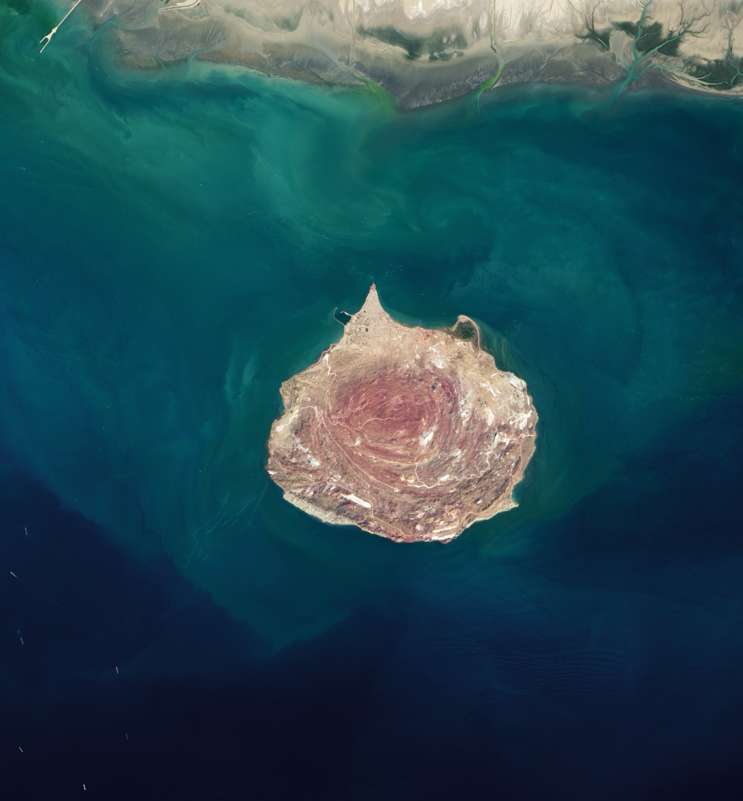 | 1 462×1 576 (908 kB) | Sysop (diskuse | příspěvky) | (Fotografie + ) |
- Editovat tento soubor v externím programu (Více informací najdete v nápovědě pro nastavení.)
Odkazy na soubor
Na soubor odkazuje tato stránka:


