V pátek 26. dubna 2024 úderem 22 hodiny začíná naše nová
a opravdu velká série soutěží o nejlepší webovou stránku !!
Proto neváhejte a začněte hned zítra soutěžit o lákavé ceny !!
a opravdu velká série soutěží o nejlepší webovou stránku !!
Proto neváhejte a začněte hned zítra soutěžit o lákavé ceny !!
Soubor:Faroe map with villages, streets, straits, firths, ferry harbours and major moutains.png
Z Multimediaexpo.cz
(Rozdíly mezi verzemi)
m (Nahrazení textu „NoveFoto100“ textem „Fotografie + NF100 + pochází z Wikimedia Commons, kde má status – Kategorie:Fotografie soutěže 2013“) |
(+ Doplnění) |
||
| (Není zobrazena jedna mezilehlá verze.) | |||
| Řádka 1: | Řádka 1: | ||
| - | + | Mapa + English: Map of the Faroe Islands with: | |
| + | * Cities and villages (yellow fields, including cultivated area). Places with a black dot are abandoned (e.g. Skarð on Kunoy) | ||
| + | * Streets between the places (red lines, if dotted, it's a tunnel.) | ||
| + | * Some major mountains (black triangles with height in metres) | ||
| + | * Ferry harbours (anchor). Note, that the Faroes have many more harbours (almost at each village at the coast). To see the ferry lines, please check the current map here: http://www.ssl.fo/ferdaatlan/images/fkort2004.jpg | ||
| + | * Major firths and straits (blue). Note, that a fjørður in Faroese is not only a firth (fjord) but can also be a strait. | ||
| + | * Major lakes are captioned | ||
| + | * What is missing on this map: Municipality borders, churches, lighthouses, heliports, hospitals, post offices, hotels and camping sites, as well as height lines, but the scale of the map doesn't allow this (IMHO). | ||
| + | * Used sources: http://www.matrikul.fo , http://www.faroestamps.fo , "Turen går til Færøerne" (Politikens Forlag, Copenhagen, 2005), "Føroyar - topografisk kort 1:100.000" (2 parts, Geodætisk Institut, Copenhagen, ca. 1985). | ||
| + | * Author: Arne | ||
| - | + pochází z Wikimedia Commons, kde má status – | + | + pochází z Wikimedia Commons, kde má status – Creative Commons Attribution-Share Alike 2.5 Generic, 2.0 Generic and 1.0 Generic license. |
| - | [[Kategorie: | + | [[Kategorie:CC fotografie]] |
| + | [[Kategorie:Maps of the Faroe Islands]] | ||
| + | [[Kategorie:Maps of Denmark]] | ||
Aktuální verze z 29. 8. 2016, 08:06
Mapa + English: Map of the Faroe Islands with:
- Cities and villages (yellow fields, including cultivated area). Places with a black dot are abandoned (e.g. Skarð on Kunoy)
- Streets between the places (red lines, if dotted, it's a tunnel.)
- Some major mountains (black triangles with height in metres)
- Ferry harbours (anchor). Note, that the Faroes have many more harbours (almost at each village at the coast). To see the ferry lines, please check the current map here: http://www.ssl.fo/ferdaatlan/images/fkort2004.jpg
- Major firths and straits (blue). Note, that a fjørður in Faroese is not only a firth (fjord) but can also be a strait.
- Major lakes are captioned
- What is missing on this map: Municipality borders, churches, lighthouses, heliports, hospitals, post offices, hotels and camping sites, as well as height lines, but the scale of the map doesn't allow this (IMHO).
- Used sources: http://www.matrikul.fo , http://www.faroestamps.fo , "Turen går til Færøerne" (Politikens Forlag, Copenhagen, 2005), "Føroyar - topografisk kort 1:100.000" (2 parts, Geodætisk Institut, Copenhagen, ca. 1985).
- Author: Arne
+ pochází z Wikimedia Commons, kde má status – Creative Commons Attribution-Share Alike 2.5 Generic, 2.0 Generic and 1.0 Generic license.
Historie souboru
Kliknutím na datum a čas se zobrazí tehdejší verze souboru.
| Datum a čas | Náhled | Rozměry | Uživatel | Komentář | |
|---|---|---|---|---|---|
| současná | 6. 5. 2014, 12:35 | 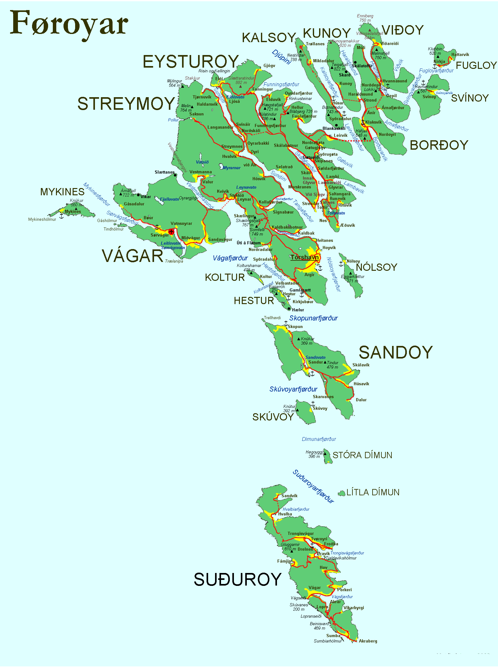 | 1 584×2 121 (370 kB) | Ulysses (diskuse | příspěvky) | (NoveFoto100) |
- Editovat tento soubor v externím programu (Více informací najdete v nápovědě pro nastavení.)
Odkazy na soubor
Na soubor odkazuje tato stránka:


