V pátek 26. dubna 2024 úderem 22 hodiny začíná naše nová
a opravdu velká série soutěží o nejlepší webovou stránku !!
Proto neváhejte a začněte hned zítra soutěžit o lákavé ceny !!
a opravdu velká série soutěží o nejlepší webovou stránku !!
Proto neváhejte a začněte hned zítra soutěžit o lákavé ceny !!
Výsledky hledání
Z Multimediaexpo.cz
Stránky s odpovídajícím názvem

Soubor:Mid Devon , Country Lane and Grand Western Canal Car Park - geograph.org.uk - 1332632.jpg 640×218 (64 935 bajtů) - 11. 9. 2023, 09:07
Soubor:Mid Devon , Country Road and Grand Western Canal Gate - geograph.org.uk - 1332457.jpg 640×152 (33 231 bajtů) - 11. 9. 2023, 09:09
Stránky s odpovídajícím textem
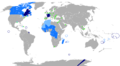
Soubor:New-Map-Francophone World.PNG ** Vietnam, Cambodia and Laos are no longer colored in light blue, this is because French is not use ** Lebanon, Tunisia, Mauritania, Morocco, and Algeria have been colored light blue, because the French language is widely2 664×1 468 (102 864 bajtů) - 9. 12. 2016, 00:40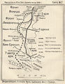
Soubor:Brusilov offensive.jpg ...ted line). Arrows show the direction of attacks of the 3rd, 8th, 11th, 7th and 9th armies (the last unlabeled). The offensive's original objective, Lembur [[Kategorie:Military maps by country]]755×977 (905 174 bajtů) - 16. 9. 2021, 07:46
Soubor:Independence Day-Kuala Lumpur-Malaysia-HDR1.jpg ... this day. For me as a german it is sometimes a bit hard to be proud of my country because of what has happened in the past. ... than overwhelming to see how all these people identify with their country and I nearly cried as all of them sang the national anthem in one voice.4 287×2 843 (5 754 476 bajtů) - 5. 2. 2015, 00:41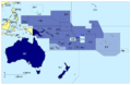
Soubor:Members of Pacific Island Forum.png ... pt · en country and territory code. SVG format. Map legend in Portuguese and English. ** WF: (pt) Wallis e Futuna (França) · (en) Wallis and Futuna (France) · (fr) Wallis-et-Futuna1 000×650 (130 582 bajtů) - 28. 11. 2015, 16:54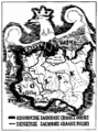
Soubor:Historyczne Zachodnie Granice Polski.gif ...contemporary and claimed historical ones, including large parts of Germany and Czechoslovakia ... work is in the public domain in its country of origin and other countries and areas where the copyright term is the author's life plus 70 years or less.604×814 (27 370 bajtů) - 12. 10. 2016, 18:14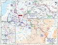
Soubor:Western Front 1917.jpg Mapa + Description: Map of the Western Front, 1917 ...o the Great War (specifically 16. Western Front, 1917, The Battle of Arras and the Second Battle of the Aisne)1 242×961 (233 585 bajtů) - 31. 8. 2021, 12:49
Soubor:Apachean ca.18-century.png ** WA (red map region) – Western Apache (Apacheeg ar c'hornôg) Tonto, Coyotero; ** Present-day state and country borders are provided for reference.863×730 (143 886 bajtů) - 21. 12. 2021, 11:34


Ukázat (20 předchozích | 20 následujících) (20 | 50 | 100 | 250 | 500).