V pátek 26. dubna 2024 úderem 22 hodiny začíná naše nová
a opravdu velká série soutěží o nejlepší webovou stránku !!
Proto neváhejte a začněte hned zítra soutěžit o lákavé ceny !!
a opravdu velká série soutěží o nejlepší webovou stránku !!
Proto neváhejte a začněte hned zítra soutěžit o lákavé ceny !!
Výsledky hledání
Z Multimediaexpo.cz
Stránky s odpovídajícím názvem
Soubor:Marl Bet Meir formation road 593 from Ariel city in Shomron to road 60 2th KM C.JPG 2 592×1 944 (1 438 241 bajtů) - 27. 5. 2020, 15:42
Soubor:Miskovice KM CZ CoA.png 249×290 (2 196 bajtů) - 20. 3. 2017, 14:06
Soubor:Vrbka KM CZ CoA.jpg 600×600 (65 831 bajtů) - 14. 3. 2017, 01:00
Soubor:Miskovice KM CZ flag.png 600×400 (1 957 bajtů) - 20. 3. 2017, 14:06
Soubor:Vrbka KM CZ flag.png 600×400 (4 286 bajtů) - 14. 3. 2017, 01:00
Soubor:Moon and Asteroids 1 to 10 at 10 km per px.png 626×380 (7 230 bajtů) - 27. 2. 2023, 18:13
Soubor:Dřínov (KM), zámek, celkový pohled.jpg 4 000×3 000 (3 900 711 bajtů) - 7. 10. 2014, 16:56
Soubor:KM Kroměříž.png 1 268×1 600 (98 796 bajtů) - 5. 9. 2015, 20:33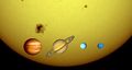
Soubor:Gas giants and the Sun (1 px = 1000 km).jpg 1 046×561 (30 109 bajtů) - 7. 12. 2014, 11:03
Soubor:Cove 1 km NW of Sorisdale, Coll - geograph.org.uk - 671628.jpg 640×425 (51 632 bajtů) - 12. 11. 2017, 10:52
Soubor:Farm track 2 Km west of Red House Farm - geograph.org.uk - 583639.jpg 640×480 (145 164 bajtů) - 29. 1. 2018, 12:48
Soubor:Sheepfold 1 Km west of Elsdonburn Shank - geograph.org.uk - 570847.jpg 640×480 (147 090 bajtů) - 17. 1. 2018, 12:07
Soubor:The B727 two Km east of Borgue village - geograph.org.uk - 571729.jpg 640×480 (181 519 bajtů) - 24. 2. 2018, 13:21
Soubor:The A709 3 Km south west of Lochmaben - geograph.org.uk - 570903.jpg 640×480 (138 361 bajtů) - 24. 2. 2018, 13:20
Soubor:Track junction 1 Km west of Red House Farm - geograph.org.uk - 583638.jpg 640×480 (156 018 bajtů) - 19. 4. 2018, 15:29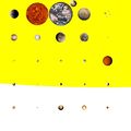
Soubor:Petits corps (1 px = 100 km).jpg ...ll bodies of the solar system of 400+ km diameter, at the scale 1 px = 100 km ... Venus, the Earth and the Moon, Mars, the four main belt asteroids of 400+ km size (1 Ceres, 2 Pallas, 4 Vesta and 10 Hygiea)700×700 (35 038 bajtů) - 26. 8. 2018, 13:50
Soubor:East Mill Tor 2 km east of High Willhayes - geograph.org.uk - 38042.jpg 640×426 (161 240 bajtů) - 21. 11. 2020, 13:40
Soubor:3000 (miles-km) to New York - geograph.org.uk - 14551.jpg 640×480 (133 898 bajtů) - 21. 11. 2020, 13:37
Soubor:Cairn at Simon Howe, 2.5 km south of Goathland - geograph.org.uk - 93328.jpg 640×480 (104 464 bajtů) - 23. 11. 2020, 10:30
Soubor:View from low hill 1 Km S of Rishton - geograph.org.uk - 39358.jpg 640×427 (85 865 bajtů) - 1. 2. 2021, 15:33


,_z%C3%A1mek,_celkov%C3%BD_pohled.jpg)

.jpg)


.jpg)

_to_New_York_-_geograph.org.uk_-_14551.jpg)


Stránky s odpovídajícím textem

Soubor:ISS015-E-6319 - View of Belgium.jpg * Altitude: 176 nautical miles (326 km)3 032×2 008 (2 118 873 bajtů) - 7. 9. 2023, 08:55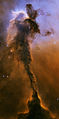
Soubor:Stellar spire eagle nebula.jpg ...s small piece of the Eagle Nebula is 57 trillion miles long (91.7 trillion km). + pochází z Wikimedia Commons, kde má status - Public domain (because3 857×7 804 (37 043 216 bajtů) - 9. 11. 2013, 15:05
Soubor:Pandora from Avatar.jpg ...my first day had about 10 km of unforgettable pain. 10 km is one thing. 10 km that involves these kinds of verticals is another thing.3 900×5 562 (17 756 120 bajtů) - 9. 11. 2013, 14:45
Soubor:Moon PIA00304.jpg ...ing from 400 to 600 km in width, and an irregular depressed floor about 12 km in depth.1 719×1 719 (318 818 bajtů) - 12. 8. 2021, 09:01
Soubor:Jupiter Earth Comparison.png * Approximate scale is 240 km/px.800×600 (262 688 bajtů) - 11. 12. 2018, 11:52
Soubor:Craters on Ganymede.jpg ... a distinctive central peak. The crater to the south is Achelous. It is 32 km in diameter. A characteristic feature of both craters, almost identical in813×753 (196 433 bajtů) - 23. 7. 2019, 10:47
Soubor:1973-05-27 Jacky Ickx, Ferrari 312P.jpg * Datum: 27.05.1973 beim 1000-km-Rennen auf dem Nürburgring * Sonstiges: Ickx/Redman gewannen das Rennen in 5:36:53,4 Std. = 178,944 km/h2 335×1 553 (1 600 185 bajtů) - 2. 7. 2013, 11:27
Soubor:Iorotateing1day.ogg ... but much more muted than shown here. Image resolutions range from 1 to 10 km/pixel along the equator, with the poorest coverage centered on longitude 50(3 320 303 bajtů) - 25. 4. 2013, 00:06
Soubor:Bradley Wiggins 2-casovka TDF 2012.jpg Fotografie + Bradley Wiggins (Arc-et-Senans – Besançon, časovka: 41,5 km, 9. července 2012)....this photo was taken on July 9, 2012 using a Nikon D2 848×4 288 (3 325 500 bajtů) - 27. 4. 2013, 21:13
Soubor:Soldier at Dukla-theodevil.jpg ...cond visit to this memorial (what is a big shame on me, since it's like 40 km from where I lived).1 000×667 (494 284 bajtů) - 30. 6. 2017, 06:36
Soubor:Mirador del Rio Lanzarote HDR 2.jpg ...r graceful) is a volcanic island in the Canary Islands of Spain, located 2 km north of the island of Lanzarote with the strait named Río. It was formed1 500×1 000 (1 119 029 bajtů) - 15. 5. 2013, 11:03
Soubor:Renfe-AVE Atocha Railway Station FLICKR.jpg ...a (AVE) is a service of high speed trains operating at speeds of up to 300 km/h (186 mph) on dedicated track in Spain. The name is literally translated f1 500×998 (652 189 bajtů) - 15. 5. 2013, 09:48
Soubor:Puerta del Sol, Madrid, HDR.jpg ...is one of the best known and busiest places in Madrid. This is the centre (Km 0) of the radial network of Spanish roads. The square also contains the fam2 000×1 328 (2 242 299 bajtů) - 24. 5. 2013, 10:38
Soubor:Alstom AGV Cerhenice img 0365.jpg Fotografie + Česky: Vlak Alstom AGV jedoucí rychlostí 200 km/h po cerhenickém testovacím okruhu. 28 June 2008 + pochází z Wikimedia3 456×2 304 (4 740 596 bajtů) - 24. 5. 2013, 19:43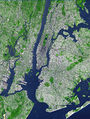
Soubor:Aster newyorkcity lrg.jpg ...d NASA's Terra satellite. The scene spans an area that is 27 km wide by 37 km tall. Vegetated land surface is green, paved urban areas are a whitish blue1 964×2 607 (3 471 119 bajtů) - 26. 5. 2013, 19:52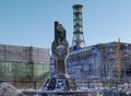
Soubor:Nuclear Winter in Chernobyl Flickr.jpg After I made it through the 30 KM security radiation zone, where Will was detained by the military for not ha3 900×2 848 (2 593 484 bajtů) - 25. 5. 2013, 16:19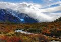
Soubor:About to cross the stream on the hike, approaching the blue glacier.jpg This is about 20 km into our backpacking. The fertile soil from recent glaciation sprang colorf5 760×4 032 (6 597 640 bajtů) - 28. 5. 2013, 15:42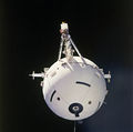
Soubor:STS-46 TSS-1.jpg ...of a satellite which is attached by a wire tether from distances up to 100 km from the Orbiter. These free-flying satellites are used as observation plat3 000×2 978 (6 114 449 bajtů) - 27. 6. 2013, 20:41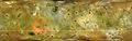
Soubor:Io from Galileo and Voyager Orbiters.jpg ... but much more muted than shown here. Image resolutions range from 1 to 10 km/pixel along the equator, with the poorest coverage centered on longitude 5011 445×3 643 (3 430 939 bajtů) - 15. 4. 2021, 09:46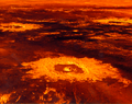
Soubor:Mgn p39146.png ...nd (28.6S,337.1E), 47.6 km Danilova (26.35S,337.25E) to the left, and 62.7 km Aglaonice to the right (26.5S,340E). The image was created by superimposing1 151×910 (1 893 853 bajtů) - 2. 2. 2014, 20:31


Ukázat (20 předchozích | 20 následujících) (20 | 50 | 100 | 250 | 500).