V pátek 26. dubna 2024 úderem 22 hodiny začíná naše nová
a opravdu velká série soutěží o nejlepší webovou stránku !!
Proto neváhejte a začněte hned zítra soutěžit o lákavé ceny !!
a opravdu velká série soutěží o nejlepší webovou stránku !!
Proto neváhejte a začněte hned zítra soutěžit o lákavé ceny !!
Výsledky hledání
Z Multimediaexpo.cz
Stránky s odpovídajícím názvem

Soubor:Coast west of Rubha na Beirghe - geograph.org.uk - 1254888.jpg 640×480 (83 118 bajtů) - 22. 11. 2023, 11:40
Soubor:Coast path on West High Down - geograph.org.uk - 697155.jpg 640×540 (102 458 bajtů) - 8. 6. 2017, 08:06
Soubor:Coast path on West High Down - geograph.org.uk - 697153.jpg 640×480 (88 415 bajtů) - 8. 6. 2017, 08:06
Soubor:Chiltern Main Line crossing the West Coast Main Line - geograph.org.uk - 699771.jpg 640×480 (98 598 bajtů) - 8. 6. 2017, 08:14
Soubor:Brown Head - west coast of Arran - geograph.org.uk - 679048.jpg 640×480 (188 413 bajtů) - 7. 8. 2017, 11:13
Soubor:Coast to Coast route passing West End Stores - geograph.org.uk - 649393.jpg 480×640 (63 460 bajtů) - 12. 11. 2017, 10:08
Soubor:Coast West of Lower Killeyan - geograph.org.uk - 665365.jpg 640×480 (64 175 bajtů) - 12. 11. 2017, 10:08
Soubor:West Coast Main Line railway in Watford - geograph.org.uk - 694793.jpg 640×480 (106 794 bajtů) - 28. 4. 2019, 12:16
Soubor:Wembury, on the South West Coast Path - geograph.org.uk - 680436.jpg 640×421 (134 271 bajtů) - 28. 4. 2019, 12:16
Soubor:South West Coast Path at Botallack - geograph.org.uk - 655093.jpg 640×427 (62 410 bajtů) - 28. 4. 2019, 12:31
Soubor:South West Coast Path - inland route - geograph.org.uk - 617444.jpg 640×477 (69 060 bajtů) - 28. 4. 2019, 12:31
Soubor:South West Coast Path - inland route - geograph.org.uk - 617453.jpg 640×477 (113 155 bajtů) - 28. 4. 2019, 12:31
Soubor:The West Coast Mainline north of Oxenholme - geograph.org.uk - 606505.jpg 640×569 (92 965 bajtů) - 8. 10. 2017, 14:12
Soubor:West Coast Main Line passing under Kilburn Bridge - geograph.org.uk - 622824.jpg 640×480 (108 811 bajtů) - 7. 10. 2017, 09:26
Soubor:West Coast Main Line near Milnthorpe - geograph.org.uk - 606804.jpg 640×634 (112 806 bajtů) - 7. 10. 2017, 09:26
Soubor:West coast of Lantivit Bay - geograph.org.uk - 664989.jpg 640×617 (116 671 bajtů) - 7. 10. 2017, 09:26
Soubor:West Coast Main Line at Docker - geograph.org.uk - 601239.jpg 565×640 (88 204 bajtů) - 7. 10. 2017, 09:26
Soubor:West side of Coast Guard Tower - geograph.org.uk - 657804.jpg 640×480 (60 712 bajtů) - 7. 10. 2017, 09:26
Soubor:View from coast path, West High Down - geograph.org.uk - 697176.jpg 640×480 (75 856 bajtů) - 1. 10. 2017, 12:44
Soubor:Coast path looking west - geograph.org.uk - 565011.jpg 640×427 (102 822 bajtů) - 29. 1. 2018, 14:04


Stránky s odpovídajícím textem
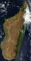
Soubor:Satellite image of Madagascar in September 2003.jpg ...rip of green along the east coast of the island is a rain forest. The west coast is lined with baobabs, a desert tree with a fat trunk, and thorny forest.3 214×6 164 (3 084 013 bajtů) - 3. 3. 2021, 10:21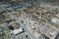
Soubor:Hurricane katrina damage gulfport mississippi.jpg .... Hurricane Katrina caused extensive damage all along the Mississippi gulf coast. FEMA/Mark Wolfe Hurricane Katrina damage in Long Beach, Mississippi, which is west of Gulfport and east of Pass Christian. Picture taken looking north on Jeff3 008×2 000 (2 771 783 bajtů) - 29. 5. 2013, 11:09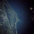
Soubor:Cape canaveral.jpg ...s. Interstate Highway 95 is the main artery traversing south to north just west of the Florida cities of Cocoa and Titusville.)5 320×5 266 (8 163 743 bajtů) - 3. 7. 2013, 05:04
Soubor:Reagans with Queen Elizabeth II and Prince Philip.jpg ...and Mrs. Reagan during a state dinner. The Queen was on a tour of the West Coast of the United States.3 000×1 975 (1 875 456 bajtů) - 19. 9. 2022, 11:59
Soubor:Endeavour silhouette STS-130.jpg ...uth latitude and 80.5 west longitude, over the South Pacific Ocean off the coast of southern Chile, with an altitude of 183 nautical miles when the image wa6 048×4 032 (701 964 bajtů) - 10. 10. 2013, 10:37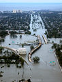
Soubor:KatrinaNewOrleansFlooded edit2.jpg ...rmath of Hurricane Katrina (2005:08:29 17:24:22), showing Interstate 10 at West End Boulevard, looking towards Lake Pontchartrain. ...n end of I-610, which extends off the photo from the center right, and the West End entrance/exit from I-10.1 153×1 514 (1 286 958 bajtů) - 3. 8. 2014, 14:41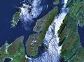
Soubor:Wfm jura landsat.jpg Fotografie + English: The island of Jura off the west coast of Scotland. The large island to the southwest is Islay, and north of it is1 280×948 (336 082 bajtů) - 17. 12. 2021, 14:12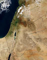
Soubor:MiddleEast-A2003031-0820-250m.jpg ...n the center is Jordan. The lush, green vegetation along the Mediterranean coast and surrounding the Sea of Galilee (Lake Tiberias) in northern Israel and s2 200×2 800 (1 831 731 bajtů) - 18. 8. 2018, 22:45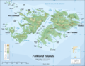
Soubor:Falkland Islands topographic map-en.png ...he coast of Argentina. They consist of two main islands, East Falkland and West Falkland, together with about 700 smaller islands. Stanley, on East Falklan ...es argentines. Il est composé de deux îles principales, East Falkland et West Falkland, et de 700 autres îles et îlots. Stanley, sur East Falkland, est2 000×1 561 (1 522 070 bajtů) - 24. 4. 2015, 01:03
Soubor:Regions of NZ Numbered.png * 13. West Coast Region290×415 (38 739 bajtů) - 3. 6. 2015, 02:00
Soubor:Belfort (2521881040).jpg ... Bruges (Dutch: Brugge) is the capital and largest city of the province of West Flanders in the Flemish Region of Belgium. It is located in the northwest o ...ity amounts to more than 13,840 hectares, including 193.7 hectares off the coast, at Zeebrugge ("Seabruges" in literal translation). The city's total popula4 288×2 847 (5 827 674 bajtů) - 2. 2. 2018, 00:29
Soubor:HST STS-61 refurbishing.jpg ...effrey Hoffman are seen during the last of the five EVAs. Australia's west coast can be seen in the background.530×724 (472 913 bajtů) - 15. 7. 2014, 19:36
Soubor:F8F-1 CV-40 landing Nov 1948.jpg ... embarked was on a world cruise from the U.S. West Coast the the U.S. East Coast from 1 Oct 1948 to 21 Feb 1949. The two fighter squadrons of CVG-1 flew the740×580 (126 850 bajtů) - 24. 1. 2021, 16:05
Soubor:Porto Covo August 2010-18a.jpg GIGANTICKÁ Fotografie + Description: The port of Porto Covo, west coast of Portugal8 006×3 430 (20 530 198 bajtů) - 30. 1. 2015, 11:03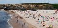
Soubor:Porto Covo pano June 2011-2b.jpg ...tografie + English: Praia Grande (Large Beach) in Summer. Porto Covo, west coast of Portugal9 197×4 512 (28 636 417 bajtů) - 30. 1. 2015, 14:34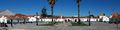
Soubor:Porto Covo March 2010-1.jpg ... Fotografie + English: The main square of the village of Porto Covo, west coast of Portugal10 461×2 589 (21 050 887 bajtů) - 29. 1. 2015, 19:48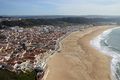
Soubor:Nazaré February 2013-1.jpg GIGANTICKÁ Fotografie + English: The beach of Nazaré, west coast of Portugal. View from the old town (sítio)7 360×4 912 (24 613 585 bajtů) - 14. 2. 2015, 12:52
Soubor:Hugh llewelyn 390 005 (6395421325).jpg ...high speed express 9-car emu No.390 005 "City of Liverpool" of Virgin West Coast at Euston on a Liverpool Lime Street service, 07/08.4 592×3 056 (3 306 180 bajtů) - 4. 2. 2017, 00:17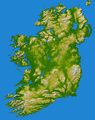
Soubor:Topography Ireland.jpg ...al in the west and north-west and in Counties Down and Wicklow on the east coast, while a basalt plateau covers much of the north-east of the country. The c * Location: 53.5 degrees North latitude, 8 degrees West longitude6 587×8 336 (6 802 315 bajtů) - 12. 8. 2018, 13:35
Soubor:TOP 80 MINIPLANE.jpg Fotografie + Description: English: At west coast3 888×2 592 (4 332 603 bajtů) - 1. 10. 2018, 09:55


.jpg)


.jpg)


Ukázat (20 předchozích | 20 následujících) (20 | 50 | 100 | 250 | 500).