V encyklopedii Allmultimedia.cz byl aktivován špičkový grafický skin Foreground.
Foreground plně podporuje – RWD, HTML 5.0, Super Galerii a YouTube 2.0 !
Foreground plně podporuje – RWD, HTML 5.0, Super Galerii a YouTube 2.0 !
Soubor:EasternBloc BorderChange38-48.png
Z Multimediaexpo.cz

Velikost tohoto náhledu je: 369 × 599 pixelů
Obrázek ve vyšším rozlišení (rozměr: 2 000 × 3 247 pixelů, velikost souboru: 874 kB, MIME typ: image/png)
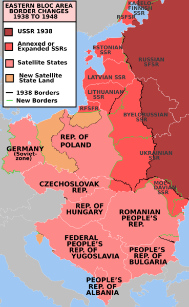
Mapa + Description: Former Eastern Bloc area border changes between 1938 and 1948.
- Date: June 1, 2009
- The border and other changes include:
- The creation of the satellite states (note: this was before the Tito-Stalin split and the Hoxha 1960 split)
- The annexation of the Baltic states
- The annexation of the territory encompassing most of the Moldavian SSR.
- The Transnistria transfer from the Ukrainian SSR to the Moldavian SSR
- The annexation of northern Bukovina, the Hertza region and northern Bessarabia into the Ukrainian SSR.
- The annexation of the area in 1948 approximating the Izmail Oblast into the Ukrainian SSR
- The western part of the Territories of Poland annexed by the Soviet Union
- The annexation into Poland of part of East Prussia and the territories east of the Oder-Neisse line from Germany
- The annexation into Poland of the Free City of Danzig
- The annexation of the the area now approximating the Kaliningrad Oblast into the RSFSR
- The annexation into Bulgaria of Southern Dobruja from Romania
- The annexation into Czechoslovakia of the Bratislava Bridgehead transfer from Hungary
- The transfer of the Latvian SSR eastern Abrene district to the RSFSR
- The transfer of Estonian SSR territories north and South of Lake Peipus to the RSFSR
- The annexation of the Vilnius region from Poland into what was in 1948 the Lithuanian SSR
- The annexation of part of the area approximating Karelo-Finnish SSR, and portions then transferred to the RSFSR (part of the Leningrad Oblast)
- The annexation into the Ukrainian SSR of Carpathian Ruthenia
- The annexation into Yugoslavia of the Italian Istria peninsula, Fiume and Zadar.
- Author: Mosedschurte
+ pochází z Wikimedia Commons, kde má status – GNU Free Documentation License, Version 1.2 or any later version published by the Free Software Foundation.
Historie souboru
Kliknutím na datum a čas se zobrazí tehdejší verze souboru.
| Datum a čas | Náhled | Rozměry | Uživatel | Komentář | |
|---|---|---|---|---|---|
| současná | 23. 1. 2015, 15:08 |  | 2 000×3 247 (874 kB) | Sysop (diskuse | příspěvky) | (Mapa + Description: Former Eastern Bloc area border changes between 1938 and 1948. * Date: June 1, 2009 * The border and other changes include: ** The creation of the satellite states (note: this was before the Tito-Stalin split and the Hoxha 1960 split) ) |
- Editovat tento soubor v externím programu (Více informací najdete v nápovědě pro nastavení.)
Odkazy na soubor
Na soubor odkazují tyto 2 stránky:
