The English encyclopedia Allmultimedia.org will be launched in two phases.
The final launch of the Allmultimedia.org will take place on February 24, 2026
(shortly after the 2026 Winter Olympics).
Dovolená : 23. prosinec 2025 — 29. prosinec 2025
Holidays : December 23, 2025 — December 29, 2025
The final launch of the Allmultimedia.org will take place on February 24, 2026
(shortly after the 2026 Winter Olympics).
Dovolená : 23. prosinec 2025 — 29. prosinec 2025
Holidays : December 23, 2025 — December 29, 2025
Soubor:Electoral map.png
Z Multimediaexpo.cz
Velikost tohoto náhledu je: 800 × 494 pixelů
Obrázek ve vyšším rozlišení (rozměr: 1 000 × 618 pixelů, velikost souboru: 191 kB, MIME typ: image/png)
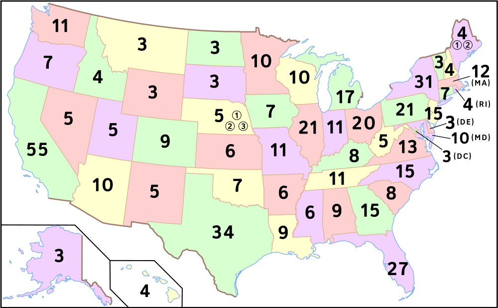
Mapa + Description: Map of number of electoral votes by state after redistricting from the 2000 census. Modified by User:Theshibboleth for the font to be consistent with electoral maps. Edited with Inkscape. Reuploaded by User:King of Hearts to correct spelling.
- Date: 18 April 2006
- Source: Self-made by User:Scott5114, based on Image:Map of USA with state names.svg.
- Author: User:Scott5114
+ pochází z Wikimedia Commons, kde má status – This work has been released into the public domain by its author, Scott5114. This applies worldwide.
Historie souboru
Kliknutím na datum a čas se zobrazí tehdejší verze souboru.
| Datum a čas | Náhled | Rozměry | Uživatel | Komentář | |
|---|---|---|---|---|---|
| současná | 4. 8. 2015, 20:29 | | 1 000×618 (191 kB) | Sysop (diskuse | příspěvky) | (Mapa + Description: Map of number of electoral votes by state after redistricting from the 2000 census. Modified by User:Theshibboleth for the font to be consistent with electoral maps. Edited with Inkscape. Reuploaded by User:King of Hearts to correct sp) |
- Editovat tento soubor v externím programu (Více informací najdete v nápovědě pro nastavení.)
Odkazy na soubor
Na soubor odkazuje tato stránka:


