V encyklopedii Allmultimedia.cz byl aktivován špičkový grafický skin Foreground.
Foreground plně podporuje – RWD, HTML 5.0, Super Galerii a YouTube 2.0 !
Foreground plně podporuje – RWD, HTML 5.0, Super Galerii a YouTube 2.0 !
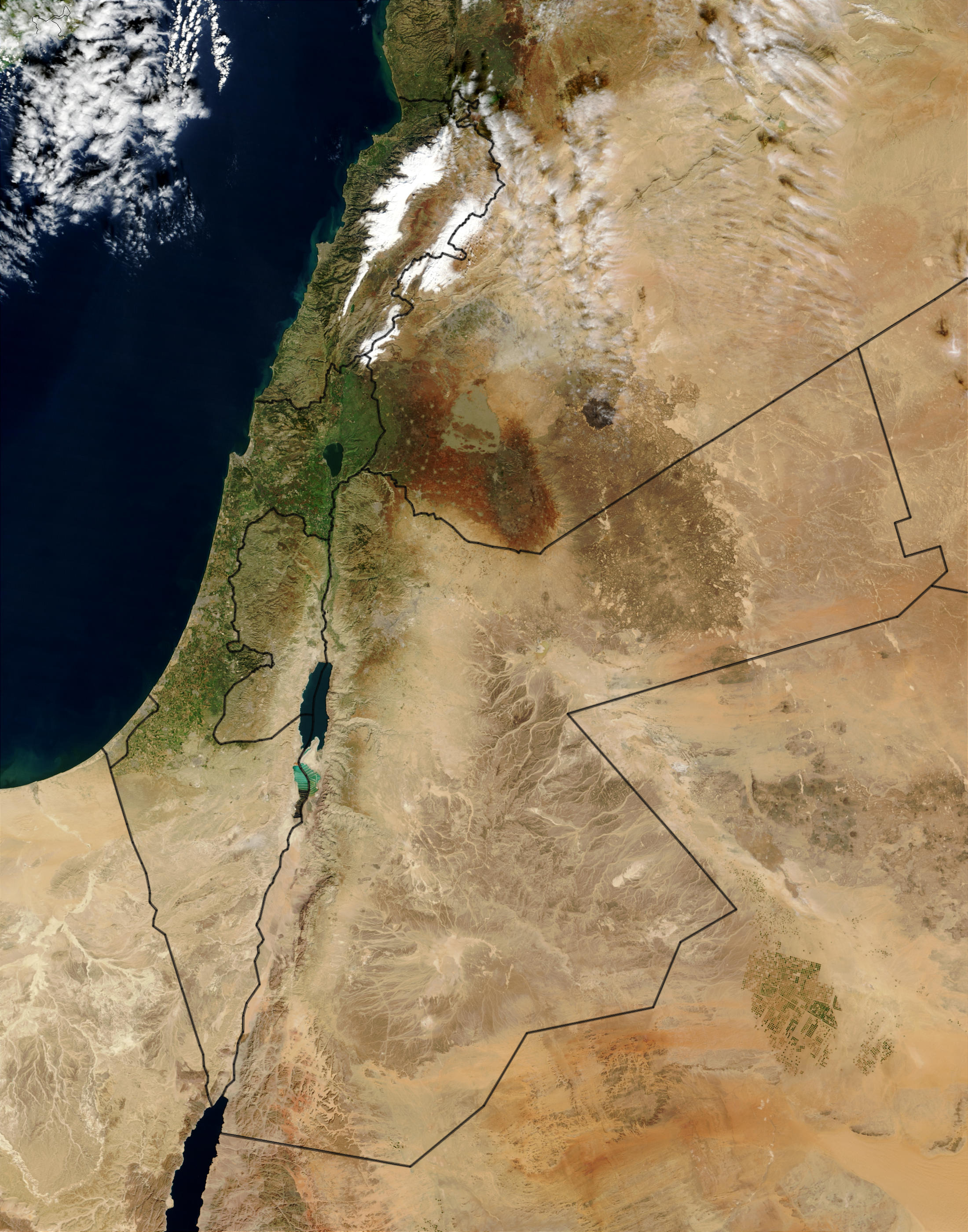
Soubor:MiddleEast-A2003031-0820-250m.jpg
Z Multimediaexpo.cz
Velikost tohoto náhledu je: 471 × 599 pixelů
Obrázek ve vyšším rozlišení (rozměr: 2 200 × 2 800 pixelů, velikost souboru: 1,75 MB, MIME typ: image/jpeg)
Mapa + Description:
- English: This Moderate Resolution Imaging Spectroradiometer (MODIS) image from the Terra satellite shows the Mediterranean Sea (left) and portions of the Middle East. Countries pictured are (clockwise from top right) Syria, Iraq, Saudi Arabia, Egypt (across the Gulf of Aqaba), Israel, the disputed West Bank Territory, and Lebanon. In the center is Jordan. The lush, green vegetation along the Mediterranean coast and surrounding the Sea of Galilee (Lake Tiberias) in northern Israel and stands in marked contrast to the arid landscape all around. In Lebanon (and the border of Lebanon and Syria), bright white snow covers the peaks of the Jebel Liban Mountains. In the bottom right, a few scattered plots of green stand out against the orange sands of the deserts of Saudi Arabia.
- Date: 14 August 2010 (according to Exif data)
- Source: https://visibleearth.nasa.gov/view.php?id=65114
- Author: Jacques Descloitres, MODIS Rapid Response Team, NASA/GSFC
+ pochází z Wikimedia Commons, kde má status – This file is in the public domain in the United States because it was solely created by NASA.
NASA copyright policy states that "NASA material is not protected by copyright unless noted".
(Use of NASA logos, insignia and emblems is restricted per U.S. law 14 CFR 1221)
NASA copyright policy states that "NASA material is not protected by copyright unless noted".
(Use of NASA logos, insignia and emblems is restricted per U.S. law 14 CFR 1221)
Historie souboru
Kliknutím na datum a čas se zobrazí tehdejší verze souboru.
| Datum a čas | Náhled | Rozměry | Uživatel | Komentář | |
|---|---|---|---|---|---|
| současná | 26. 3. 2014, 17:46 | | 2 200×2 800 (1,75 MB) | Sysop (diskuse | příspěvky) | (MW1.15-FOTO) |
- Editovat tento soubor v externím programu (Více informací najdete v nápovědě pro nastavení.)
Odkazy na soubor
Na soubor odkazuje tato stránka:


